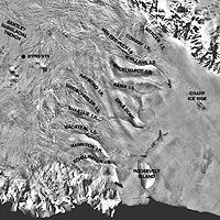
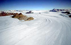
Ice Streams
The ice cap does not slowly flow radially outward in all directions. In places a deeper channel has been worn down and ice, say 10,000ft thick will flow a lot faster than ice 4,000ft thick. From the air the boundaries of the ice stream or “channel glacier” can be plainly seen. The biggest is the Lambert Glacier which flows to the sea over in the Australian sector, it is up to 80 km wide and flows near the sea at a rate of about 1 km per year into the Amery Ice shelf at Prydz Bay. In actual fact, the Lambert appears to consist of a series of ice streams which flow into a tectonic depression and become channelled into an outlet glacier which forms a large ice-shelf where it enters a widening bay. The Ross Ice shelf is largely built from several ice-streams flowing out of the West-Antarctic Ice Sheet, (WAIS) , as well as by Outlet Glaciers flowing through the mountains from the EAIS.
|__| Satellite view of the Lambert Glacier (to come later.)
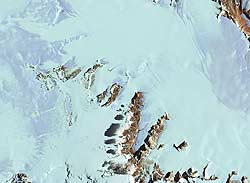
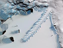
 << Satellite view of the ice streams of West Antarctica. Alternating ice streams separated by ice ridges flow towards the Ross Ice Shelf on lower right.
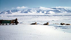
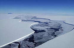
The Bay of Whales is the inlet formed downstream of Roosevelt Island. At least five bases have been built there, on what can only be a very unstable site, but the ice edge is low enough to unload a ship. To think that the original Byrd Station was built by materials towed in by tractor train from Bay of Whales. If the drivers has seen this satellite view they might well have said “No way!” I think only one was killed. There are sharp differences in flow rate along the margins of the ice streams, which are really almost submerged Outlet Glaciers. The possibility that this lot could break up and melt suddenly would seem about as likely as NZ suddenly sinking below the sea, the central ice plateau being well confined by mountains whatever it’s base level might be!
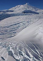
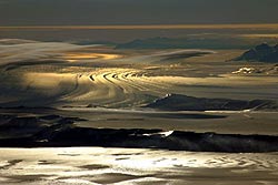 Some pix are more art than science, though science is far from being mere boring unromantic “facts” as it so often represented. Here, with the sun low in the SW looking north over the trianglar Dominion Range, we see the Beardmore joined by the Mill Glacier on the right wending it’s timeless way. In five or six hundred years it will reach the Ross Shelf and float off. In another 2000 years it will reach the Barrier face and break away to form some huge flat-topped ice-island. In 3000 years time people in a passing ship may say, “There’s a big berg I wonder where it came from!” Some pix are more art than science, though science is far from being mere boring unromantic “facts” as it so often represented. Here, with the sun low in the SW looking north over the trianglar Dominion Range, we see the Beardmore joined by the Mill Glacier on the right wending it’s timeless way. In five or six hundred years it will reach the Ross Shelf and float off. In another 2000 years it will reach the Barrier face and break away to form some huge flat-topped ice-island. In 3000 years time people in a passing ship may say, “There’s a big berg I wonder where it came from!”If ice could not bend and flow under it’s own weight, of course, all the water of the world would be locked up at the poles. Our habitat was planned very carefully! |
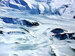
Outlet Glaciers
The Antarctic Ice cap has existed for at least 25 million years which is about the same age as the Victoria Mountains which form an almost impenetrable dam to ice flowing towards the Pacific. However at intervals ice has a some time risen high enough to top the mountain range and begin flowing down eastwards towards the Ross Ice shelf. As a channel was worn deeper, the ice flow increased, even so the ice is still backed up an average altitude of 9 – 10,000 feet on the west of the ranges. These massive glaciers draining enormous amounts of ice to the sea or to the Ross Ice-shelf are called “Outlet Glaciers”. read more about Outlet Glaciers at https://www.britannica.com/science/outlet-glacier
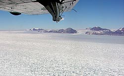
To the north of McMurdo the Drygalski, the David, Mawson and Mackay Glaciers are outlet type. To the south are the Ferrar, the Skelton, Mulock, Darwin, Barne, Shackleton, Beardmore, Liv, Axel Heiberg, Reedy and others less well known. The Shackleton and Barne (= Byrd) are up to 20 miles wide and we first saw them when on an aerial photographic mission in late 1955. Members of Scott’s Expeditions had seen the gaps in the mountains but were too far off to see the glaciers and so named the gaps “Inlets”, eg the “Barne Inlet”. I simply wrote in “Glacier” on the old 1903 maps and crossed out “Inlet”, so “Skelton Inlet” became “Skelton Glacier” and so on for the Mulock, Barne, Shackelton (= “Nimrod”), etc.
Charles Swithinbank and others have since measured their flow rates and more recently flow rates have been measured by satellite. Up to 800m a year flow is seen in the Byrd Glacier. More detail will be added later.
Darwin GlacierThe Darwin with it’s tributary, the Hatherton, occurs immediately north of the Barne (= Byrd) and south of the Mulock Glaciers and resembles greatly the FerrarTaylor. Like them, they are starved of plateaux ice by encircling dolerite sills, the ice flow is slow, (one source gives an average of 150 m/a), there are no mountains high enough to encourage local snow fall or trap drift and while there is no major dry valley there is considerable snow-free rock and some melt-water lakes.
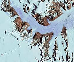
<< Satellite view, unfortunately incomplete, by the USGS of broad Darwin Glacier to the north and the more deeply incised Hatherton Glacier and its tributaries to the south. Because of many doleritic screes, the Beacon does not stand out but occurs at the prominent junction of the Hatherton and McCraw Glaciers (site of the ‘Mt Derrick” meteorite find.) and while post tectonic granites are known to intrude Ross System and Byrd group metasedimentary rocks near the Ross Ice shelf, we cannot at this point identify the range. We hope to add a geological map. Tectonically there area is quite different to the northern side of the Nimrod for example where block-faulted parallel ranges are so well displayed. The Darwin is a well known area for collecting meteorites from the blue ice west of Meteorite Ridge seen in the upper Darwin, left. A cluster of five nickel-irons were found on the prominent point projecting from the south bank of the Hatherton on Derrick Peak. In 1958 the two members of the TAE Darwin Party Mr Roy Carlyon and the well-known Waiho (= Franz Josef Glacier) chief guide Mr Harry Ayres with two dog teams came from Dept 400 which lies out on the ice-cap into the area. After the well-known adventure when Ayres lost his entire team and sledge down a crevass, (saving himself by throwing himself to one side) they recovered everything including the dogs which were swinging in air from their harnesses, after a days hard work and carried on. Their first survey station was at Westhaven Nunatak which is not shown but lies immediately west of the range on the south bank of the Hatherton. At the end of the field season they were joined by pilot Wm Cranfield and Scott Base cook Selwyn Bucknell (a one time shooter and possum trapper for DOC) for the hazardous descent of the icy Darwin onto the Ross Barrier. Carlyon’s laconic field diary is a delight to read. At least two other parties have gone up the Hatherton by skidoo and been airlifted out from the plateau, another went up the Darwin and McCleary Glacier to Ayres and Carlyon’s “Festive Plateau” and the Cook Range. |
|||
Mackay GlacierThe Mackay Glacier is a large outlet glacier flowing from the polar plareau through the South Victoria Land Mountains into Grantite Harbour about a hundred miles north of McMurdo Sound. It is the first glacier occurring north of the Dry Valley area.
This is the only pic available taking by a person who is not identified. It is not the best so we hope someone may take a better. There are many signs of lowering of ice level, in the abraded sides of Mt Suess (middle left) and the iceworn benches on the near side of it, (Gondola Ridge). Queer Mountain and Sperm Bluff, (middle distance left) are also ice polished. Prominent dolerite sills form bars across the egress from the plateau seen in far distance, and these block the ice flow. The deeper Mawson Glacier to the north has “captured” ice that once flowed down the Mackay. Skew Peak rises to 9000ft+ in distance above the leftmost of the twin summits on Mt Suess. Mt Gran (named for Trygve Gran, the Norwegian ski expert with Scott in 1910-13 and who was part of the Granite Harbour party with Taylor, Debenham and Forde) lies in the right distance and is capped with Beacon Sandstone and a thin sill. The eroded dolerite sill that caps Mt Suess lies on the Kukri Peneplain cut across granite of the Granite Harbour Intrusives. Both Taylor and Co and Warren and I found Devonian fish fragments in the moraines on near side of Mt Suess. In 1957 we came through the Miller Glacier to the left of Suess and passed up between Suess and Sperm Bluff and to the left of the doleritic Pegtop Nunatak halfway up and left again around Detour Nunatk. Near the distant bluff beyond Pegtop we crossed to the northern side and found an easy egress to the Plateau. It was the fifth crossing of the mountains. The glacier forms an ice tongue where it flows into the sea at Granite Harbour a few miles lower down. Dome Nunatak ploughs bravely through the ice in the centre. |
|||
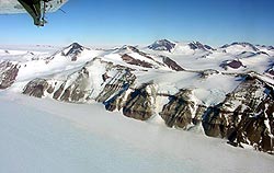
Nimrod Glacier
The transition from Goldie Fm (Beardmore Group) pre-Cambrian greywackes (Gunn and Walcott,1962) to Shackleton and Byrd Group archaeocyathine Limestones takes place at the prominent bluff on the left and also at the dark Cambrian Bluff on the right in the Holyoak Range, (Laird, 1963). Limestones can be seen at the 15,000ft summit of Mt Clements Markham immediately south in the chapter on ‘Landforms, Big Mountains”. More Goldie Fm and Hope Granites are found in the Nash Range, (out of sight, right foreground). The Geologists Range in the distance is of Beacon Sandstone and Ferrar Dolerite. South of it and out of sight lies the Miller Range with the high grade gneisses of the Nimrod Gp, with several formations of high-grade marble, sillimanite gneisses, garnet amphibolites, fuchsite schists etc (Grindley etal, 1963; Gunn & Walcott, 1962) which are now taken to be pre-Cambrian in age. On the right the mountains consist of four successive fault blocks and those of the west must be considerably more elevated. The Lowery Glacier enters from the Queen Elizabeth Range on left. Photo: Beth Bartel, Jan. 2004. |
|||
| Beardmore Glacier | |||
 << Buckley “Island” is a small range surrounded by ice on the north side of the Beardmore immediately below the Ice-cap edge. Perhaps the yellowish rock below the Beacon Sandstones is the famous Cambrian (~<540myr) limestone with the coral Archaeocyathus found by Shackleton, 1909, (see David & Priestley, 1914). Note the north-easterIy dip of the Beacon. In this range also Scott in 1912 found Permo-carboniferous coal, now called the Buckley Coal Measures. Analagous Dominion Coal Measures occur to the east in the Dominion Range and the upper Shackleton Glacier. (See George Grindley, et al, Ant.Geol. SCAR Proc.1963). No geologist seems to have looked at Buckley Id. in almost a hundred years. Photo: Dr John Isbell Dec. 2003 << Buckley “Island” is a small range surrounded by ice on the north side of the Beardmore immediately below the Ice-cap edge. Perhaps the yellowish rock below the Beacon Sandstones is the famous Cambrian (~<540myr) limestone with the coral Archaeocyathus found by Shackleton, 1909, (see David & Priestley, 1914). Note the north-easterIy dip of the Beacon. In this range also Scott in 1912 found Permo-carboniferous coal, now called the Buckley Coal Measures. Analagous Dominion Coal Measures occur to the east in the Dominion Range and the upper Shackleton Glacier. (See George Grindley, et al, Ant.Geol. SCAR Proc.1963). No geologist seems to have looked at Buckley Id. in almost a hundred years. Photo: Dr John Isbell Dec. 2003 |
|||
 << The upper Beardmore, view W taken from over Plunket Pt. at the northern end of the Dominion Range. This broken surface is an unusual phenomena, it appears to be a combination of a compressive flow crevasse pattern overprinting a tensional flow crevasse pattern. Possibly the patterns are still visible because it is formed in very cold conditions. The surface of the lower Barne (=Byrd) Glacier is rather like this but more rounded being more ablated. We can see why returning support parties of Scott got into such difficulties when they strayed out of a smooth lane. While there is little drift snow, few of the breaks seem open. This photo is continuous with the one above. Photo: Dr John Isbell Dec. 2003 << The upper Beardmore, view W taken from over Plunket Pt. at the northern end of the Dominion Range. This broken surface is an unusual phenomena, it appears to be a combination of a compressive flow crevasse pattern overprinting a tensional flow crevasse pattern. Possibly the patterns are still visible because it is formed in very cold conditions. The surface of the lower Barne (=Byrd) Glacier is rather like this but more rounded being more ablated. We can see why returning support parties of Scott got into such difficulties when they strayed out of a smooth lane. While there is little drift snow, few of the breaks seem open. This photo is continuous with the one above. Photo: Dr John Isbell Dec. 2003 |
|||
 << The Queen Alexander Range, view W across the upper Beardmore about 50 miles below Mt Buckley. The scarp in the foreground was called the “Marshall Mts”, and was the backdrop to the famous picture of Shackleton, Marshal and Frank Wild resting on their sledge in 1908. << The Queen Alexander Range, view W across the upper Beardmore about 50 miles below Mt Buckley. The scarp in the foreground was called the “Marshall Mts”, and was the backdrop to the famous picture of Shackleton, Marshal and Frank Wild resting on their sledge in 1908.“The Cloud Maker” lies further right down glacier. The peak in the distance MAY be Mt Falla,(4300m) Mt Kirkpatrick OUGHT to be somewhat to the right. See the much smoother surface on the glacier below but it is windswept blue ice. Photo Dr John Isbell, 2003. |
|||
 |
Shackleton Glacier, about 50 miles to the east of the Beardmore. A major Outlet Glacier, the Shackleton is now used as a route to the Plateau instead of the Beardmore. | ||
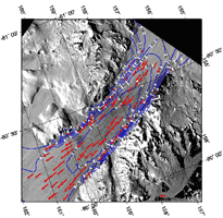 |
Satellite view of the Barne (= Byrd) Glacier.
Flow rates are given in m per yr, see scale lower left. The flow rates as it enters the Ross Shelf are fairly constant, it is probably afloat. |
||

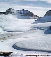
Mountain Glaciers
Glaciers smaller than the outlets arise within the mountains themselves from a combination of snowfall and windblown drift. They arise in a snow-collecting basin or neve, flow down a rock-walled valley and may flow into the sea, into another glacier or into the Ross Ice-shelf.
 An interesting aerial image allegedly from the Beardmore area, but unidentified (USGS Image Library.) Photo: Dr Bill Servais |
<< Notice the sharp inter-cirque ridges extending down to the snow, evidently the ice level has not been higher for tens of thousands of years, nor has there been any retreat though possibly there has been a slight advance.
This has finally been identified as the Upper Lowery Glacier. Mt Clements Markham lies out of sight, top left.
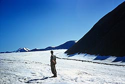
 Cirque or Corrie Glaciers: Inland Forts, Upper Taylor
From the lower slopes of Round Mtn, Upper Taylor Glacier. Wright Valley to North, ie, middle right.
Thin, virtually stagnant ice slabs extruding from corrie glaciers in the Inland Forts which are Beacon Sandstone and capped as usual with dolerite. A pass through to the Wright Valley lies in the right foreground, (see “Passes” in “Landforms”). November 1961.
Wall-sided Glaciers
 On top of the Commonwealth Glacier. Note lack of lateral moraines, and presence of an ablation hollow. (Jan 1956)  The Commonwealth wall-sided glacier. Taylor Valley, January, 1956
|

These do not really occur anywhere in the world except in the Dry Valleys and in similar valleys in Northern Ellesmere Land and Northern Greenland. Small mountain glaciers flow into dry valleys which were once occupied by an Outlet glacier but down which ice no longer flows because of “ice capture” by a bigger nearby outlet, or because of mountain uplift. The tributary reaches the floor of the dry valley, and with no walls to contain it, expands outwards in an “expanded foot”. Dirt bands near the base are formed by sub-glacial till being brought to the surface along shear surfaces, the ice being under “compressive” flow. Reflection of heat from bare rock causes accelerated melting especially near the base, so the expanded foot terminates in steep cliffs or “wall sides”. The Commonwealth Glacier in the Wright valley is a classic example. Wright & Priestley first defined them after the 1910-12 Scott Expedition. Probable annual layers can be seen in the ice face but discontinuities must occur at the shear zones.
Has any retreat taken place over the last 48 years? Locate these points and take another pic. I have asked to be set down for 3 minutes to do this on three occasions and been turned down every time. I doubt they have moved more than inches. Pics taken Jan.1956. I think the meltwater stream in the upper shot flows into Lake Fryxell, and the lower one into the sea.>
|__| Commonwealth Glacier seen from the air (to come later.)
 << Not only dying little tributary glaciers are wall sided. This is the side of the Taylor Outlet Glacier near Beacon Heights. Reflected heat from the wall rock produces marginal cliffs. Lack of marginal crevassing suggests the Taylor is almost stagnant at this point. Ice flow is actually from left to right. Wilson swore he would get up the thing! We did – but not just here!
Photo, Dec 1961.
Piedmont Glaciers
 The Oats Piedmont Glacier lies in front of the Kirkwood Range between Granite Harbour and the Mawson Glacier and Nordenskiold Ice Tongue. |
“Piedmont” means “Mountain-foot” or, “At the foot of the Mountains”. All the way from southern McMurdo Sound to Terra Nova Bay there is a coastal plain half a dozen miles wide, only a hundred feet or so high at the coast and sloping up gently west till it abuts onto the lower slopes of the Victoria Mountains, which shoot up to 3-6000 ft. This coastal plain is covered by a thinnish slab of ice which moves very little but is cut through at intervals by the outlet and mountain glaciers which reach the sea.
The origins of these ‘Piedmont Glaciers” is rather uncertain. Being close to the open sea all summer they get quite a heavy local snowfall which does not extend into the Dry Valleys. It may be that over the centuries the Piedmonts have worn the coastal rocks down into a low plain. On the other hand it may be structural, the Royal Society Range and the Victoria Mts in general are block-faulted parallel to the coast. Are the piedmonts a down-thrown block on which ice accumulates? Unless we can match a rock type in the piedmonts with one occurring in the coastal ranges we cannot prove either, and the rocks are a folded complex of schists and granites with no marker horizons. Another possibility is that the piedmonts are a former raised beach dating from an early inter-glacial period.
Sastrugi
 large sastrugi on the Ice cap, about 100 miles SW of Upper Mawson Glacier, 1957 at about 1000ft alt. |
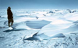
Occasionally when out on the Barrier or up on the Ice Cap one may get a few inches of snow. If it is not blowing already it soon will, and the lighter snow lifts a few inches or feet above the ground and is whirled away. This is called “drift”. The heavier snow heaps up into crecent-shaped barchan dunes just like sand dunes with the horns pointed downwind. The wind packs them hard and they form an icy crust and your nice travelling surface has been transformed into a series of hummocks over which sno-cats etc crash and sledges bang and as there is no more fine powdery snow, there is no more drift. But the wind will pick up small ice fragments and carry them along and these begin cutting into the “barchan”-like drift accumulations. After a few days they will have cut channels through them.
Up on the ice-cap this becomes extreme and channels several feet deep are cut through the hummocks. As the “drift-chiselling” is more active low down, the hummocks become under cut, until they can look like upturned canoes on pedestals, and may stand 4-5 feet above the channels the wind and drift has cut. It is impossible to sledge or drive across “sastrugi” like these and one is forced to turn and travel along the line of the channels. Once on the ice cap we had to travel for three days to the south-west when we wanted to go south-east. Eventually we came out of them, or we may have ended up in Vostok!
 The wind scupts some odd snow formations. |
 Buried, hidden crevasses can be tricky and give the driver that sinking feeling. On the Staircase, Skelton Glacier, 1959 USARP Scott Base to Pole traverse, lead by Dr John Weihaupt. |
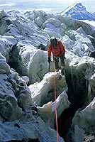
Crevasses
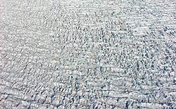
Ice can never flow as a sheet. It seldom flows faster than a few feet per day and it can slowly bend but under tension will usually crack. These cracks are called “crevasses”. If ice flows down a rock-walled valley as a glacier it will flow faster on top than at the bottom and faster in the middle than at the sides. This develops tensions which cause a chevron pattern of crevasses to form, the most crevasse-free place being in the middle of the glacier. Along the edges near the rock, crevasses may gape 20 feet wide and occur every fifty yards or so. An almost stagnant glacier may have almost no crevasses at all. If the gradient in a glacier sharply steepens as the ice flows over a hard band of rock, there will be gaping crevasses at right angles to the path of flow, especially near the break in slope at the top. Even if buried in snow, again you know they will be there. Only a complete fool would ever drive a vehicle over a sudden drop in the surface of a glacier.
 << Above the Finger Mountain Corner in the Taylor Glacier, the edge gets rather broken. Here Wilson picks his way off the ice in 1961. Round Mountain in the distance shows a large block of Beacon afloat in dolerite. Hereabouts Ferrar found the first permo-triassic plant fossils in lateral moraine, we found more and found it in place further up, part of what is now called the “Weller Coal Measures”.
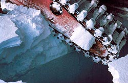
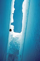 A body is hauled towards the survace after the 1959 sno-cat accident near Cape Selbourne. See the way the sagging lid has grown as the crevass slowly opened. |
Wind-drifted snow may partly fill them, or form a lid which can be inches to feet thick. A sharp jab with an ice axe will often go right through. Very large crevasses may be 20 – 50 feet wide and be lidded, the lid being a sagging bridge of triangular shape, sometime so solid you can walk over and not know they are there. A tractor or vehicle may cause it to fall in. Don’t believe the clever remarks about the low ground pressure of Sno-cats. Six tons on a crevasses lid is exactly six tons extra weight!
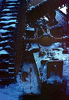 Sno-cat 100ft down the mine near Cape Selbourne, near the Barne (Byrd) Glacier. This happened to the NZARP party the same day as the event above right. Believe it or not 2 of 3 survived. |
Few things cause shortness of breath more effectively than the feeling of a leg suddenly going through and you find one foot is resting on several hundred feet of air.
Where a glacier is forced to turn round a bend big pressure ridges form on the inside of the bend and very large crevasses on the outside of the bend. They may be buried under snow cover, but you know they are there so always walk with a rope on, they can be 2-300 feet deep. Again only a congenital idiot would select a route around the outside of a bend. This hole occurred on a flat slab of grounded ice several miles across on the edge of the Ross Shelf. It hadn’t orta a been there! It was worse than sneaky, it was plain deceitful but it got us!.
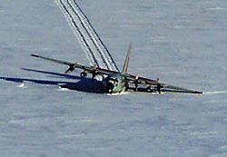 See how well even deeply buried crevasses stand out from the air! This Herc found one running A to B after passing over one at point C. (See englargement) |
Crevasses have a special vindictiveness all of their own. They can be there, buried under 3 feet of soft snow, on a flat area without a sign of a hump or anything to cause them. They have been sitting there for hundreds of years just waiting for some amiable idiot to come wandering past or driving over! To the experienced eye, a crack in the snow an inch wide 50 yards to one side means, “I am about to step over a buried crevasse maybe 3 feet wide.!” [Prod! Prod!] “Ah! Thought so!”
|
Note man inspecting damage within the crevasse! |

In bad country one man leads prodding the snow. Your best man comes second, when he see the first man suddenly drop, he gives a heave on the rope. Result? The first man finds himself sitting on the lip of a crevasses with his feet dangling and no harm done. The third man is there just in case the second man is a bit slow, pulling someone up who has gone down 6 -10 feet and is swinging in the air, takes two men. I have done it only once, the lead man was a bit too cocky and was insisting there was no danger so I gave him four feet of slack and waved him on. He went through and down out of sight within a dozen yards!
Windslab snow is a crust with nothing but very soft snow beneath. If you or the dogs step on it, or the sledge goes over it, it may give a “woof” and an area a hundred yards across may settle by 6 inches or so. The dogs panic and leap to one side, they think it is a crevasse, and the driver’s heart does some odd things at times!
 The Erebus ice tongue. Photo: USGS |
Ice Tongues
When an outlet or mountain glacier reaches the sea, it parts from the land and floats pushing out a tongue a mile or two long, sometimes 10 or 20 miles. Eventually, tide flow, currents or storms will cause it to break off and float away as a “tongue berg”. “The Ice Tongue” on Ross Id flows down a channel into the sea and has broken off twice since 1912, as has the Mackay Tongue. The Mawson Tongue is very long but has broken off at least once.
|__| Ice tongue at Terranova Bay, (but no re-entrants?? To come.)
 |
<< Erebus Ice Stream. An ice stream flows off the southwestern slopes of Mt Erebus almost unconfined by any visible walls and forms the Erebus Ice Tongue out in Erebus Bay. One is never afraid of crevasses like these, all wide open and very visible, (though perhaps not altogether crossable, but I have known people who would find a way). Photo: Weddell World |
 << A pic taken in May at a T of 30-40 below with little light and a frozen camera! But! In the foreground the Erebus Ice Tongue show classic re-entrant due to the different speed ice flows at on land and when afloat. Behind is the Hut Point Peninsula following the Erebus SW Rift Zone and terminating at Observation Hill Trachyte Dome. Notice how the bay ice between the glacier tongue and the peninsula is held in by Turtle Rock. The bay ice in the right foreground tends to be held in by the Dellbridge Islands. In the distance are the White Island volcanoes lying along another rift and Minna Bluff at the eastern end of the Mt Discovery Rift Zone. These days Willies Field lies this side of White Id. Taken from the Auster, May, 1957, Pilot John Claydon. << A pic taken in May at a T of 30-40 below with little light and a frozen camera! But! In the foreground the Erebus Ice Tongue show classic re-entrant due to the different speed ice flows at on land and when afloat. Behind is the Hut Point Peninsula following the Erebus SW Rift Zone and terminating at Observation Hill Trachyte Dome. Notice how the bay ice between the glacier tongue and the peninsula is held in by Turtle Rock. The bay ice in the right foreground tends to be held in by the Dellbridge Islands. In the distance are the White Island volcanoes lying along another rift and Minna Bluff at the eastern end of the Mt Discovery Rift Zone. These days Willies Field lies this side of White Id. Taken from the Auster, May, 1957, Pilot John Claydon. |
|
Ice Bergs
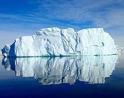 << An iceberg is usually regarded as being about the size of a ship. Tabular bergs broken off an ice shelf can be 400 miles long but break into smaller chunks within a few months. However one even 60 miles long and 2000ft thick can be quite a lump to run into!
Tabular Bergs
 Edge of a tabular berg. |
The face of the B -15A mass, freshly broken from the face of the barrier.
Even though somewhat improved by editing, we could wish more could take pix like this! Height of ice face is 2-300 ft. Note very little melting at the water contact and no “ram”.
Photo: Josh Landis
Ice Shelves
The edge of the Ice shelf (actually of the tabular berg “B -16”). Some new ice forming where the immense berg has split. Imagine the fate of a vessel taken into such a “lead” if the two halves moved together again! Beaufort Id in distance.
 An enormous separation. The edge is at least 150ft high! |
Ice shelves are thick floating ice masses attached to the continent and occurring in protected bays and bights in the land. In a bay pack ice may persist over several years and become bay ice and accumulate snowfall to become an ice shelf. However the larger Ice shelves have a great deal of ice contributed from outlet and mountain glacier tongues and the persistent bay ice between them plus accumulated snowfall. One wonders why the whole Weddell Sea is not one enormous ice shelf, as the southern Ross Sea is, but it is not quite enclosed enough and some pretty stiff ocean currents sweep round it in a clockwise direction, continuously breaking the ice up.
|__| The face of the Ross Ice Shelf (to come.)
 Erebus and Terror in a bad way. |
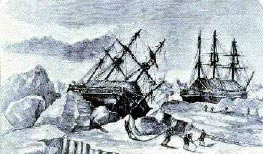
By now there must be a great deal of data on the thickness of the Ross Ice shelf at the southern end against the land, compared to the northern limit between Cape Crozier and Bay of Whales. In summer, warmer water flows under it with each tide, and there must be considerable bottom melting. We hope to get the latest thickness data and melting data and add it here. As yet the front of the Ross Ice shelf, while it calves off enormous bergs periodically, has not changed much since first seen by the “Erebus” and “Terror” in 1845. The surface of the Ross Ice Shelf is not flat but has swells and rises. At one point the horizon may only be miles away and one cannot see a thing. Then imperceptibly one climbs up out of the depression, to see the tops of mountains standing up perhaps a hundred miles away.
|__| The Bay of Whales. Here the shelf is thinned because of the existence of a rock knoll upstream called Roosevelt Island which tends to part the ice to two streams which coalesce again but form a semipermanent bay in the ice (to come.)
The Melting of Ice Shelves
The popular press and other attention getters are currently prone to dropping remarks such as “Rising world temperatures may result in the melting of Ice Shelves and the West Antarctic Ice Sheet bringing catastrophic rises in sea level, which may cover the floor of you sea-side holiday home!” etc. Some refer to the complete submergence of New York and places like Holland and Pacific Islands.
Pacific Islands of course have had no trouble in keeping above sea level in spite of the rise of >100m since the last glacial period 10,000 years ago, but coral is now having a hard time due to factors like people fishing among reefs by tossing in hand-grenades or poison. This may be seen in the dead coral in islands off Lombok in Indonesia. A great deal of coral is dying in the Pacific, eg in the Tonga Group and Great Barrier Reef due to the “Crown of Thorns” starfish which is exploding in numbers because their natural enemies the Helmet Shellfish and Giant Triton is being exterminated by people selling their shells to tourists. Excessively hot summers are also blamed but corals have stood up to higher temperatures before this. However, without actively-growing coral, Pacific atolls may indeed be in trouble.
Ice shelves have a precarious existence with the inflow of glacier ice and accumulated snow having to match the loss along the frontal face by calving of icebergs. In cold winters ice may be frozen onto their lower surfaces, in a warm summer with seawater flowing in under them with the tides, there is some thinning due to melting of the lower surface. This is partly counterbalanced by the fact that water is heaviest at 4ºC so that any surface water that warms up to 4ºC promptly sinks to the bottom. I have never lowered a thermometer to the bottom of the Tongan Trench at 32,000ft depth, but I know what the temperature is, it is VERY close to 4ºC. Curiously enough, though I have fallen into it I do not know what the surface temperature in McMurdo Sound is at the height of summer, but it is for at least 2 months, high enough to melt the sea-ice. Let us qualify that, it become warm enough not to freeze, the thinning of ice pack takes place mainly from the top on sunny days.
Suppose we have a horrendous increase in summer temperatures, warm water flows under the Ross Ice Shelf and thins it from its present thickness to, say 500ft. It would then be less able to resist cracking by northerly swells and the face could retreat by say a hundred miles. What is the effect going to be on world sea-levels? Absolutely none, as a floating body displaces its own weight of water, as that Greek fellow (Archimedes) realised when he was taking a bath.
Suppose we have a population that has increased to 10 billion all panting out heat and CO2 and we burn four billion tons of coal a year and world temperatures rise by 5ºC. The Ross, the Ronne, the Filschner, the Larsen and the Amery Ice shelves all retreat until they reach a point where the ice is aground, even if below sea level.
However, being aground, the tide cannot flow under it, and melting is restricted to the ice front. It then becomes a matter of, does the rate of ice-flow seaward at 200-800m/yr match the rate of melting along the face? As we are now a long way further south it probably would in most cases. The Ross Ice shelf front is in actual fact, currently further north than it was in 1955.
With open seawater much closer, the humidity and snowfall would increase greatly and the average mean temperature would still be around -40ºF, at which not a great deal melts if you will pardon the sarcasm. So our southern Ice Cap as well as the Greenland one are comparatively stable structures with a great deal of inbuilt inertia and resistance to change. A little thinning might take place around the continental margins, but possibly more than offset by increased snowfall, possibly a few toes of rock might show. Sea-level could rise by a few inches, with which our civil engineers could no doubt deal with, but on the other hand if snowfall is increased enough, the ice-caps could thicken and sea-level fall. Our knowledge of climate control is not good enough at this point to be positive, so many people are simply guessing. Sea levels can change locally with prevailing winds but the Chief Oceanographer in Hawaii assures me no definite sea-level change has been detected in the last fifty years. Other sources claim rises of 0.9 to 3mm/yr, which given the rate at which mountain glaciers are going in temperate regions could be true. (Though Sweden show the highest rate of change with sea-level declining.)
In Antarctica raised beaches, eg at Gneiss Point, show that land is rising faster than the sea.
Other data show sea-levels to vary from 0 to 123m below present over the last 250,000 yr, none being higher. Claims of the possible melting of the Greenland Ice Cap with sea-level rises of 15 – 18m are not really believable, as stable continents such as Australia do not show terraces etc indicative of sea-level ever being above present.
The most unstable iceforms are probably not the ice-shelves, but the wall-sided glaciers that exist in the Dry Valleys which are very susceptible to average snow fall and mean annual temperature. I took a pic of one in 1955 (shown above) and have spent a fair amount of time trying to get permission to go back and take another pic from exactly the same point 48 years later which should reveal all. Permission has always been strongly denied, science is not rated very highly these days and politically correct opinion is all, and politically correct opinion says the ice-caps will all melt and we will all drown except for a handful of Tibetans so who am I to say different?
Long Term Climatic Changes
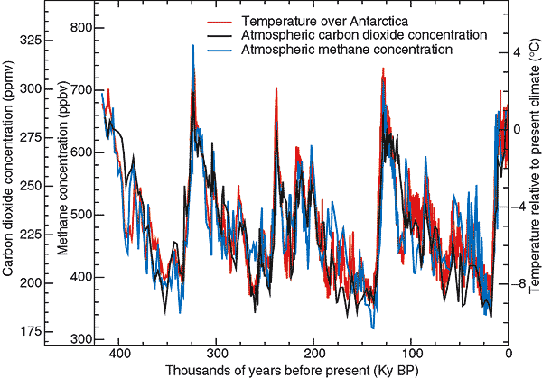
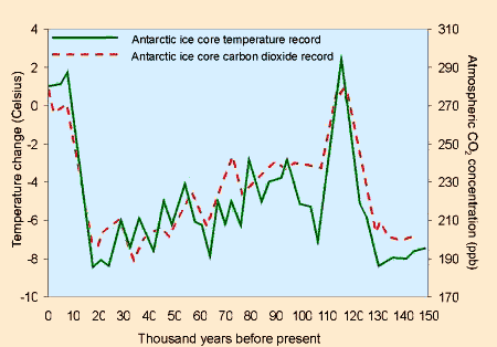
The above diagram from Petite et al, 1999 shows the results of the 2623m ice core drilled above Lake Vostok by an international consortium. While not the first it is the most convincing demonstration of climatic changes in the last half million years.
It shows four cold periods and that we are rapidly approaching the peak of a fifth interglacial. Atmospheric CO2 and CH3 closely parallel temperature but do not appear to precede it. We are approaching the peak of a global warming phase which may be expected to peak within a thousand years or so. Warming began 11,000 years ago which does not seem to altogether coincide with the northern hemisphere where the Wisconsin Ice age began at times variously given as 50,000 yrs to 125,000 yrs bp, reached a maximum at 21,000yr and began to recede rapidly at 12,000yr.
Some commentators claim that the greenhouse effect accentuates the temperature differences which are claimed to parallel the precessional orbital solar distances, others deny this. The CO2 atmospheric content has ranged from a minimum of 180 to a maximum of 290 ppm. Forest clearance and the burning of vast amounts of coal and oil, have put current CO2 levels up to 360 ppm, well above anything seen for half a million years but less that seen in the Ordovician before widespread carbonate rocks and the coal measures were laid down, when CO2 was at 4400 ppm levels and temperatures much as present day.
We are looking for the precessional variation data; please pass it on it you know of any.
Above are the results of a core taken near the Australian Mawson base, showing the detail over a single cycle from 150,000 yr to present. No less than 10 minor variations occur in between, the maximum and minimum T and CO2 support the findings of Petit et al.
Dust trapped in snow shows an inverse correlation as dust increases in cold periods due to lack of vegetation. The late Dr Harold Wellman found loess deposits between volcanic cobbles on Ross island.
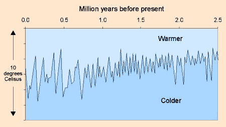
A long term diagram from cores going back to 2.5 million years. Before about 800,000 years, the glacial periods were of shorter duration.
Near the centre of the West Antarctic ice has been cored ~ 10,000ft to bedrock by the EPICA at what is called Dome C, ( E. Brook et al, 2005, Science) and extends to 650,000 yrbp. Like Vostok and the 1992 Greenland Icecap cores, (Jouvel etal, Nature 429, 2004), the same 4 prominent iceages occurring at roughly 100,000 year intervals te seen but the 500, and 600,000 yr ones are less severe and have a longer interglacial. There are no sections missing, ie both Greenland and west and East Antarctica have been icecovered continuously for 650,000 years and possibly much longer and no melting has taken place. However, throughout this time the CO2 and methane levels have been lower than they are at present.
Current Polar Climatic Trends
Apparent glacial recession is most apparent in the Dr Valley Area. As we pointed out back in 1962 (Gunn & Warren, 1962 NZ.Geol.Surv.Bull.71) this is due to the failure of the main outlet glaciers of the region to wear down their thresholds which block the flow of Plateau ice. The Mawson to the north and the Mulock and the Barne (= Byrd) Glaciers to the south have much more deeply incised thresholds. Mt Feather also plays a part in deflecting wind-blown drift.
The age of the ice maximum in the Dry Valleys now may be taken as being in the range 2.5 – 3 million years bp, based on duration of exposure of rock to radiation, to weathering, and on the presence of unglaciated volcanic rock of Late Pliocene age.
Temperature variations of the last half million years have changed the extent of grounded ice, coastal ice levels, the extent of ice-shelves and has changed sea levels so that some valleys may have become fiords as the Skelton currently is.
|___| << View of south side of the Taylor Valley showing very level lines which are not moraine lines and can only be beach lines during interglacials.
In general there has been a painfully slow retreat of ice in the Dry Valleys, as plateau supply and wind-drift were cut off. Ancient ice still persists under ablation moraine so the process is not complete. There are no prominent stranded lateral moraines or sequence of terminal moraines as seen in temperate zones to indicate even minor re-advances.
The greater mass of the East Antarctic Ice Sheet (the EAIS) seems to have remain substantially unchanged. No retreat is seen in much of NVL, in the Queen Maud Mts and the Horlick Mts. Plateau lowering and increase or reduction in ice capture may take place at any of the outlet Glaciers. Truncated spurs and underfit glaciers may occur but similar signs are not seen in neighbouring glaciers. High snow levels in NVL especially may mean the ice is locally thickening with climatic warming.
The ice cores show ice has persisted for 400,000 years beyond doubt, it is highly unlikley that major change has been seen in the last 30 myr. A series of disconformable tributary cirque glaciers can be seen in the Mt Clements Markham block NW of the Lowery Glacier (See ‘landforms, Big Mountains”). These give the appearance of being due to the recent uplift of the Queen Elizabeth range, already the highest standing block in the whole antarctic crust.
This section will be updated as further information become available.
Ice Axes
There is only one rule regarding an ice-axe and that is: Never go a dozen yards on ice or snow without one. Even on rock with an ice-axe to act as a third leg, one will never slip and fall and you cannot afford to fall when 400 miles from home. On snow you must prod for crevasses, you must be able to ram the shaft home in the snow and take a turn of the rope round it to belay another man who has “gone down the mine” or looks as though he might. Your ice-axe will protect you against a leopard seal, or an attacking skua. It will help anchor the tent in a blizzard, with it you chop ice to melt to drink. You can use it (and nothing else will do) to kill a seal for the dogs, or to save yourself from starvation in the event your chopper has crashed and there is not another within 500 miles to save you (as happened to us once.)
A really massive ice-axe is needed, it should reach your hip bone when the ferrule is on the ground, the right length for a walking stick. Antarctic ice is very hard, a light axe will shatter. I have seem people carry silly little things about 2 feet long as used as a pick on a steep ice climb, these are quite useless on the ice, one cannot even prod for crevasses with them. You may have to cut steps to cross a tide crack, or to get up an awkward bit on a mountain. I once had two men fall off on me when descending an icy couloir, a belay round the point of the pick in a tiny crack saved them, (and me). I have lost count of the times a good belay rammed into snow has stopped the fall of someone who has slipped, or had an ankle turn when on crampons. I have known the man in front go through a crevasse six times in an hour, the ice-axe saved the situation every time. I would rather be without my pants. If you left a clock or camera behind, too bad. No salt or sugar? Put up with it and learn a lesson. No ice axe or climbing rope? Go home!