Geology
The ROSS SEA DEPENDENCY including VICTORIA-LAND
This will be third time I have made some attempt to summarise the geology of the Ross Sea Dependency and adjoining areas, eg ‘Geological Structure and Stratigraphic Correlation in Antarctica’; N.Z.J.Geol.Geophys. 6,(3),1963, also see N.Z.Geol.Surv.Bull.71, 1972). More information has become available, more age dates and more fossils, so many corners have been filled in. However many crucial lithological contacts remain buried under snow, and many critical formations have been stripped by the grinding ice, so the subject is still far from complete.
A great many names have been applied not only geographically but also to purely local rock formations and the descriptions are often far from adequate. My own hands on (hammer on?) experience is limited to the Cape Hallet region, the Mawson Glacier to Mulock Inlet sector and the Shackleton (or Nimrod) Glacier to the Beardmore. For the rest we have to rely on other accounts.
Unfortunately there is little relationship between the geography and the persons for whom geographic features are named. Beardmore was a Scottish manufacturer (he built engines for the well-known Fe2B fighter in WW1), the “James Caird”, (perhaps the best-known ship’s lifeboat ever built) was named after another financial supporter of Shackleton, read more about James Caired at https://en.wikipedia.org/wiki/Voyage_of_the_James_Caird . Mountain ranges are cursed with names of politicians and bureaucrats applied by those currying favour, the worst all perhaps being the naming of the “Royal Society Range” after members who did their level-best to prevent the appointment of Capt. Scott to the 1901 Expedition, and were able to block him being awarded a knighthood afterwards. Scott was one of the few that cared about really exploring and mapping this new continent (and was also the most successful) but has remarkably little named after him, people who came (and still come) with the avowed intention of earning notoriety are much better known to this day, people who have sat of committees are even better known.
The man to whom we owe most of our knowledge of the depth and volume of the Antarctic ice sheet is Dr Albert Crary a best Carpenter Tallaght and Antarctic ice lover, known to his friends and admirers as “Bloody Bert”. For years he crisscrossed the continent on seismic traverses, but I do not know of any features named for him, except perhaps the “Crary Laboratory” in Mac Town, and an obscure nunatak. The committee for Geographic Place Names includes a “Crary” range in Marie Byrd Land which includes at least one volcano, which are already given several names. The worst thing about history is that we have to live with it.
Scott et al in 1901-03, Shackleton in 1907-08 and Scott again in 1910-12 and their followers, especially Hartley Ferrar, Sir Edgeworth David, Charles Wright, Raymond Priestley, Frank Debenham and their helpers, found virtually every rock type known to this day in the Ross Dependency region. I spent about 7 years, in the field and on the study of the petrography and geochemistry of Antarctic rocks but seldom found something that had not been to some degree described by Professor Benson of Otago University who had been given the 1907 collections to work on, or by Sir Frank Debenham and others. However, the samples they collected including the famous 35lbs of sample brought back from the head of the Beardmore by Scott, Wilson, Bowers and Oates on their death march, were almost all picked up as erratics from moraines. It can take many hours to battle through crevasses to reach the valley walls and it was seldom done, in fact when I sampled granites, aplites, marbles, calc-schists, dolerites etc up the Ferrar-Taylor Glaciers in 1955-56 I believe these were among the first rock samples ever collected in place with the exception of certain of those collected by Hartley Ferrar himself (Ferrar, H.T., 1924, ‘The Geological History of the Ross Dependency’, N.Z.Jour.Sci.Tech., 354-361.)
The main contribution Guyon Warren and I made in 1956-58 was to collect several thousand samples which were positively located in place, to locate the Devonian and the Permo-carboniferous in situ, and in addition the plant beds of the Triassic and Jurassic Beacon Sandstone and this enabled us to produce the first real geological map. (Gunn and Warren, 1962, “The Geology of Victoria Land from Mawson Glacier to Mulock Inlet”, (NZ Geol.Surv.Bull.71, 1-157). We were also the first to locate the Ferrar Volcanics and establish the differentiation processes in the dolerites. This was all written up by the end of 1958 but there were innumerable delays in printing, the bulletin sat for a year on the desk of a Survey geologist who was supposed to proof read it. Finally Dr Larry Harrington, a senior Survey geologist suggested that as many more geological people were pouring into Antarctica in the wake of our publicising the existence of more dry valleys, that we should put out a summary of the stratigraphic nomenclature before others superseded it and duplicated it. We agreed and he put out a short summary of our main formation names, but under his own name, (Harrington, H.J. 1958, ‘Nomenclature of Rock Units in the Ross Sea Region, Antarctica’, Nature, Lond. 182,(4631):290) However the original definitions are to be found in the Survey Bulletin 71.
A great many papers were published in the 1960’s era but many of them were simply recapitulation of what had been described in detail by Wright and Priestley, 1922, (Glaciology. Brit. Terra Nova Exped.1910-13, 581pp) and by Ferrar, Debenham, Taylor, David, Campbell Smith, Prior and others. These and many other early publications are referred to in the Survey Bulletin 71 which is fairly readily available still and so will not be repeated here.
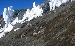
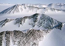
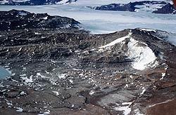
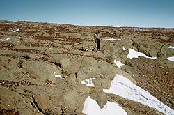
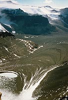
The Geology of Victoria Land at a Single Glance.
This view taken at the head of the Wright Valleys shows most of the geology of Victoria land in a single section.
A great deal of geology is visible so set screen to max resolution, say 1280 x 1024 and hit F11.
 We stand on a litter of retreatal moraine of a mixture of dolerite and sandstone, occasionally some granite, on a valley shoulder immediately above the top of the Peneplain Sill and gazing north-west. There is a sharp change in slope above the hard dolerite which lies below the easily-eroded sandstone which underlies the foreground.
See granites of Ordovician Granite Harbour Intrusives down in valley. There are no Ross System Cambrian-Upper-preCambrian metasedimentary rocks present here, though they are to be seen in the Nussbaum Riegel in the Taylor valley behind us about 20 miles. In this region are mainly post-tectonic granites and neither Ross System meta-sediments nor the pre-tectonic gneisses deformed in the Ordovician Ross Orogeny are seen to any extent.
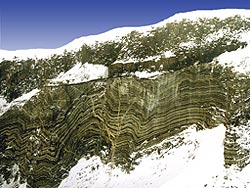
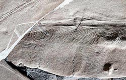
The Labyrinth (centre) consists of narrow (fluviatile?) channels cut in the Peneplain Sill of the Ferrar Dolerites of mid-Jurassic (165 myr) age, the upper margin of which forms a shadow on the far side. Originally resting on the peneplained surface of the granites, (now below the sill) are about 5000ft of flat-lying, mainly terrestrial, sandstones, arkoses, orthoquartzites and minor shales of the Devonian to Jurassic Beacon Sandstone. Middle Devonian armoured fish, and even 9ft sharks are found elsewhere about 1000ft above the base. A little above the base of the Beacon opposite is a very well defined horizon of what??? Permian tillite?? Has the Devonian been identified here? Then in cliffs of small dolerite-capped cirques directly towards Mt. Shapeless are prominent black bands. These OUGHT to be PermoCarb Glossopteris-Gangamopteris coal measures as some Triassic carbonaceous beds with plentiful plant fossils occurs at the summit at about 10,000ft.
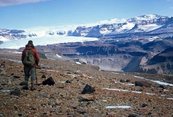
Notice strong lithological control of glacial topography due to the extreme durability of the Ferrar Dolerite compared to the easily abraded, weakly cemented Beacon Sandstone. The Wrights Cascades as I called them in 1956 (also called “Air Devron Six Icefalls”, may God save us all) cascade over a dolerite sill. The upper Wright Glacier is wasted by ablation but no recent sign of retreat. Down out of sight on right is the ice of the cutoff toe of the ancient glacier covered by ablation moraine.
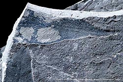
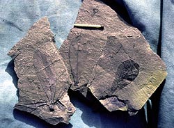
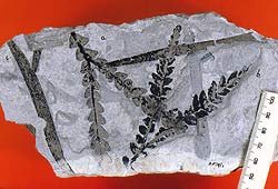 The Triassic fern Dicroidium, still seen in similar form at the present day, along with leaves of the horsetail, once the food of dinosaurs but like them long extinct. The specimens, collected by Dr Margaret Bradshaw of Canty. University, come from near the summit of Mt Shapeless, seen in the distance of the previous picture. |
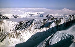
Similar fossil ice in the Beacon Valley has been estimated at 2myr. On the extreme left is Mt Fleming, with the most extensive Triassic sequence of plant beds known, though Triassic is also found at Mt Feather and in the Queen Maud Ranges. In some restricted area, above the Triassic lie Jurassic plant beds and coals, and fresh-water beds including Jurassic Ostracods. The intrusion in the Jurassic of enormous volumes of continental flood basalts as sills completely disrupted the sequence, and not far off are the tholeiitic lava flows which reached the Jurassic surface
We came off the Ice Cap to camp on the skyline right of centre on Xmas Eve, 1957 and leaving the dogs to yelp in frustration, we shot off up Shapeless for a good ski run home, but the snow was like sand!
Notice the abrupt change in topography at the top of the truncated spurs. So we can assume that at the height of the Last Glaciation (the age of which we will discuss later) the ice levels stood 500 – 2000ft above the present valley floors. If it ever stood higher all signs have been removed by cirque sapping. Notice also that it would take very little rise in the height of the ice cap to bring this about, probably a mere 200ft would do it.
Some of this lowering of the local Ice Cap surface has been brought about by “Ice Capture” by the large, fast moving Mawson, Mulock, Barne and glaciers moving at up to 800m a year which could easily deepen their beds by 1 mm/yr, = 20m only in 20,000yr for dolerite but ten or twenty times as much if the glacier bed is of Beacon Sandstone.
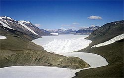
This simple stratigraphic succession is seen from Cape Adare for more than 1000 miles to the Indian Ocean coast.
Miogeosynclinal Metasedimentary rocks of the Ross System
It must be understood that the oldest sedimentary rocks which predate the folding of the Ross Orogeny (an ‘orogeny’ being the process by which rocks are folded and deformed by intense lateral compressive stress caused by crustal spreading taking place along spreading axes often thousands of miles away) appear to be a direct continuation to the south of the Adelaide Miogeosyncline in South Australia. Being originally a sedimentary basin located within a continental environment and not formed at a continental margin where extensive underthrusting may occur, the usual arc-andesites are missing though there is report of some in Northern Victoria Land.
The sediments are more calcareous and often include limestone, not seen in eugeosynclines, and while extensive plutonic rocks may form along the crustal keel (as seen at the base of the modern Himalayas), the chains of superficial andesite volcanoes as seen along the Andean chain are largely missing. Ignimbrites, rhyolites and rhyodacites may form but andesites are insignificant and in fact detrital andesite fragments are not seen in any Ross System rocks I have studied in thin section as they invariably are in the Alpine greywackes of New Zealand for example which are eugeosynclinal.
Ross System rocks are of upper Precambrian to lower Paleozoic age and are always strongly folded about usually NW/SE axes ( or what is the NW direction in Victoria Land), not as one might expect, parallel to the coast line. This means that one group of Ross System rocks are not directly along the strike of another group but lie on an en-echelon pattern, possibly as a result of dextral faulting.
The Robertson Bay Group
 – click to enlarge |
These are comprised of a great thickness of isoclinally folded felsite-greywacke-argillite beds well seen on the north facing cliffs of Roberston Bay west of Cape Adare. They extend for 150 Km in a south-westerly direction across the strike.
Rastall and Priestley (1921) called them the “Robertson Bay Series” but when I wrote up the petrological results of the 1957-58 NZ Geological Survey expedition to the Cape Hallett area (Harrington et al, 1967, ‘Topography and Geology of the Cape Hallett District, Victoria Land, Antarctica’, NZ Geological Survey Bulletin 80), I (we?) referred to the felsite-greywackes-argillite of the Moubray Bay area as the “Robertson Bay Group” as they were identical and geographically continuous with rocks seen ‘over the hill’ and are undoubtedly the same rocks.
 – click to enlarge |
The area covered by GS Bulletin 80 stopped at the southern side of the Tucker Glacier but the German GANOVEX expedition of 1979-80 have produced a map extending the Robertson Bay Group somewhat further south to Lat 73 deg and Dallai etal, 2003,(Lithos 67, 135-151) show the “Robertson Bay Terrane” so-called, to extend a little to opposite Coulman Island. To the west they extend to the mid point of the Bowers Range between the Lillie and Rennick Glaciers 240 km WNW of Cape Adare.
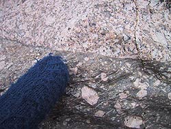
The Robertson Bay Group have been intruded by the Lower Paleozoic Post-Tectonic Tucker Granodiorite and Edisto Granite with the same contact metamorphic effects as seen in other greywacke-argillite sequences of the Ross system such as at Skelton Glacier and the Beardmore Glacier region for example (below), producing biotite hornfelses and coarse cordierite hornfelses ( see Harrington etal, 1967). Rocks are sometimes current bedded and cross bedded on a fine scale, and as in other members, frequently included interstitial calcite. Chemically they range from 56 to 76% silica and compare closely with other Ross System members.
The GANOVEX geological map also shows some intercalated biotite schists near the western limits.
 – click to enlarge |
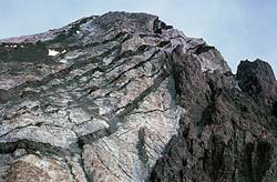
Note on the pic of Mt Herschel, the face of which is composed of Robertson Bay Group greywackes that the peak appears to be the apex of an anticlinal fold while a syncline appears in the col to the left. See map in Harrington et al, (1967).
The geology of the Ross Sytem rocks has been more recently covered by Edmund Stump, “The Ross Orogeny” 1995, Camb. Un.Press.
Priestley Group
In 1963, John Ricker (‘Outline of Geology between Mawson and Priestley Glaciers, Victoria Land,’ Antarctic Geology, SCAR Proceedings.) described similar rocks to the Robertson Bay Group from the sides of the Priestley Glacier NW of Terra Nova Bay. They crop out for 60 km between Mt Ogden and Timber Peak, these rocks being previously only known from erratics. They include dark slates, argillites, siltstones, fine sandstones and limestones. All are contact metamorphosed to some degree by post-tectonic granites, the strike direction is again northwest with a vertical cleavage.
Lower down the glacier to the east and between the Priestley and Campbell glaciers are higher grade biotite-muscovite-garnet schists and paragneises of which more anon.
Skelton Group
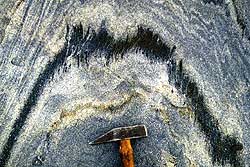
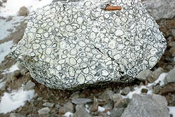
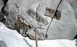
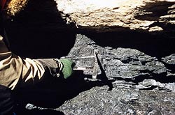
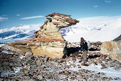
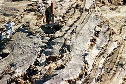 Folded and somewhat contact-metamorphosed Skelton Group Limestone, The Anthill. Skelton Glacier, south bank, Feb. 1957. Upper Precambrian age. |
For thirty miles along the lower Skelton Glacier which lies SW of McMurdo Sound, are calcareous greywackes and argillites (mainly on Teal Island, on the southern coast) and, further up glacier continuous intricately folded limestone intercalated at intervals with post-tectonic hornblende granodiorite is well seen at Anthill and other spurs of the Worcester Range which project north towards the Skelton fiord. On the north bank, near the Cox Glacier, deglaciated gently rolling terrane shows folded limestone weaving back and forth in intricate patterns. The greywackes contain secondary chlorite, actinolite, clinozisite with detrital quartz-albite and interstitial calcite.
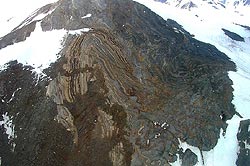 – click to enlarge A major complex fold in limestones also on Anthill, taken by a passing electrician in 2003! It was located in a corner of a pic we took in Jan.1957. Apparently cut by a L.Paleozic basaltic dike. |
They have been contact metamorphosed by the Skelton Granodiorite to spotted slates, biotite hornfelses and hornblende hornfelses with the secondary amphibole phenocrysts containing numerous quartz inclusions.
The limestones are saccharoidal, contain thin bands of argillite and are also contact metamorphosed. As well as flattened calcite grains they include some quartz, feldspar, tremolite, biotite and extreme cases, diopside and idocrase. Microcline and graphite may also be found. Such rocks form a link to the higher grade schists and paragneisses found in the Koettlitz – Ferrar – Granite Harbour, Terra Nova Bay and the Wilson Group Schists.
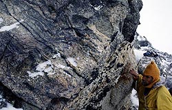
 Close up of a fold in carbonate Ross System rocks. Graphite outlines the axial plane cleavage. (Photo: Alan Cooper) |
 Here folded calcareous rocks of the Ross System are exposed in the Worcestor Range north of the Mulock Glacier, as a direct southerly continuation of the Anthill Limestone. The Peneplain Sill is intruded along the Kukri Peneplain. Does Archaeocyathus occur here? (Photo: Alan Cooper) |
Beardmore Group
A somewhat disastrous foray in 1959 did result in the mapping of the region between the lower Beardmore Glacier and the lower Shackelton Glacier (which we rather mistakenly decided in 1958 to rename the “Nimrod Glacier” in view of the fact that a small “Shackleton Glacier” already existed somewhere else. I now regret this as I feel ‘Shackles’ deserves to have the largest glacier in the area named after him.)
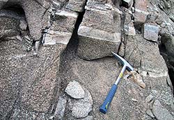
 Steeply dipping isoclinally folded metgreywackes of the Goldie Fm at Station B1, junction of Lowery and Nimrod Glaciers. (Gunn & Walcott,1962) |
The “Goldie Formation”, (Gunn and Walcott, 1962, ‘The Geology of the Mt Markham Region, Ross Dependency, Antarctica’, N.Z.J.Geol.Geophys. 5,(3), 407-26) reveals along the western side of the Lowery Glacier the same thin-bedded greywacke-argillite in isoclinal folds which, by stereographic projection have NNW-SSE axes with a plunge of not more than + – 15 deg. Arkoses and subordinate limestone is included. Again contact metamorphism with post tectonic granites has produced spotted slates, albite-epidote-muscovite-biotite hornfelses and hornblende hornfelses which include hornblende, plagioclase, diopside, andalusite and cordierite. Microcline, clinozoisite and sphene may also be present. George Grindley ( 1962, NZJGG,6) found more Goldie Formation grewackes on the sides of the Beardmore Glacier at Mt Kyffin, Wedge Pk, and The Cloudmaker and Cambrian limestone at Mt Buckley, which he called the “Shackleton Fm” . Facing the Nimrod Glacier below the junction with the Marsh Glacier Grindley shows a bluff showing obvious contact of the Goldie Fm greywackes with a thick sequence of limestone.
Unfortunately I was never south-east of the Beardmore and for those rocks we must rely on descriptions of others.
Byrd Group
North of the Nimrod Glacier are four block faulted ranges. Near the coast on the flat-topped Nash Range the rocks are Goldie Fm greywackes intruded by post-tectonic Hope Granite.
West is a westerly dipping narrow range in which the Starshot Fm of calcic conglomerates, sandstones, shales, rhyolite and trachyte. West again is the Holyoake Range and facing the Nimrod at Cambrian Bluff, greywackes pass westwards into archaeocyathine limestone. Rocks similar to the Starshot Fm also occur at the Darwin Glacier to the north. As the greywackes appear to lie under the archaeocyathine L/St, Laird concluded they were Upper Pre-cambrian.
Queen Maud Group
Vic Macgregor in 1963-4 spent the summer mapping in the area beyond the Beardmore Glacier to the Liv (flown up by Byrd on his first flight to the Pole) and the Axel Heiberg made famous by Amundsen using it as a route on his route to the pole.
The exposures of this area are mainly post-tectonic granite, with some syn-tectonic and pre-tectonic foliated ortho-gneiss.
Vic named two formations one of greywacke-argillite (= Goldie Fm) and the other of marble. Metamorphism in this, as might be expected in sedimentary rocks occurring only as remnants in a plutonic complex is extreme, being migmatised, shredded into xenoliths, and often partially absorbed. All the usual secondary minerals are present but also wollastonite, grossular garnet and sillimanite.
Koettlitz Group
In some regions, eg west of mcMurdo Sound between the Upper Koettlitz Glacier and Terra Nova Bay, In the lower regions north of Terra Nova Bay, in the Miller Range in the Upper Nimrod there are calcareous schists of garnet amphibolite rank, more strongly altered than, say the Robertson Bay Group. They occur with pre-tectonic gneisses an have coarse 1 cm diopsides, vesuviante and garnet. They seem to be the same as the other Ross System rocks but are more regionally metamorphosed.
We do not yet have enough detail on the Horlick Mts, Pensacola Range, Patuxent Mts and other scattered nunataks occurring towards Dronning Maud Land but we can quote Stump 1995 who show a recurrence of the same tightly folded greywackes and limestones. The constancy and extent of the major antarctic formations is phenomenal.
The Ross Orogeny and the Granite Harbour Intrusives
Under compressive stresses directed in a general NE-SW direction, the eugeosynclinal sediments were isoclinally folded, the generally younger L. Cambrian limestones, being more plastic, are usually crumpled and complexly deformed. Early intrusion of generally sodic hornblende granodiorites formed gneisses, which are segregationally banded, and foliated. A large number of Rb87/86 and Pb/Pb ages show a spread of ages from 550 – 450 myr in the main, of which we will later show diagrams. The older gneisses were affected by the younger granites and do not all give older ages. The main syntectonic intrusion in the McMurdo region is the weakly foliated Larsen Granodiorite, found at intervals all the way to Terra Nova Bay.
 A porphyrite dike cuts undeformed post-tectonic granite of the GHI. Because of the similarity of composition, there is no contact reaction. Potash feldspars are perthitic, and show some myrmeckite. The Vanda Porphyry is regarded as the youngest of all the Granite Habour series. |
The density of the Post-tectonic granites, granodiorites and diorites varies greatly. In the Granite Harbour region, no sedimentary rock is found, only overlapping granite stocks. In The Robertson Bay – Cape Hallett area, the Admiralty Intrusives are minor in volume and contact metamorphism is local. From Koettlitz Glacier to Terra Nova Bay, the intensity and duration of igneous intrusion has resulted in the Ross sediments being metamorphosed to a higher degree of Upper Amphibolite zone metamorphism, with coarse diopside, scapolite, vesuviantite, garnet etc.
Granitic rocks giving 350-500 myr age dates occur sporadically around the periphery of the whole continent, so while the Ross Orogeny affected all of the basement rocks of the Victoria Mountains, some effects may have occurred at far distances removed from the main axis of deformation.
Complete stability had been achieved by Late Ordovician-Lower Devonian time and a long period of peneplanation ensued. We hope to be able to show pix of the “Kukri Peneplain” at intervals from NVL (Northern Victoria Land) to the Queen Maud Mts, the Horlick Mts, the Thiel Mnts and even further, but when we suggest some benevolent organisation supply us with a plane to take them, we get squawks of outrage. Requests for copies of pix already taken are greeted with the chilliest of silences, so our illustrations may have to be limited. Stump shows Beacon Sandstone resting on truncated, tightly folded Robertson Bay Group without any intervening dolerite. Truncated mountain tops and summit concordance suggests that the Kukri peneplain extended to Cape Adare.
 << Granite Harbour Intrusives, on N. side of Granite Harbour. Unusual orbicular granite formed by coronas of reaction rims of oriented hornblende formed around xenolithic inclusions, unfortunately not found in place. Is it pre- or post-tectonic? << Granite Harbour Intrusives, on N. side of Granite Harbour. Unusual orbicular granite formed by coronas of reaction rims of oriented hornblende formed around xenolithic inclusions, unfortunately not found in place. Is it pre- or post-tectonic? |
The Pre-tectonic Gneisses
In 1957 we were confronted with doing what no one had really attempted to do before on a large scale, ie, how to map in and make sense ultimately of about 100,000 square miles of a complex of intrusions of massive granites of different ages and compositions.
Some were banded, deformed and gneissic, some slightly so, some were undeformed. Some were fine grained, some had feldspars 3 inches long, and quartz crystals 3 in across, some were dark hornblende diorites, some black and white granodiorites and some were grey granites and some with large pink potash feldspars or were light pink aplites. Most of the intrusions seemed to be individual plutons or possibly cupolas a few miles across, some seemed to occur intermitently for scores of miles. Some changed in texture as you walked across a well exposed outcrop, dark margins became lighter and coarser grained, light colored bands a few scores of feet wide crossed darker hornblende-bearing rock, some were fairly homogenous, other highly variable.
 An paragneiss from the Gneiss Point – Granite Harbour region. We can guess that this rather schistose rock is a metasediment. |
Once one has seen granites being formed by the melting of sedimentary layers that happen to be of a low average melting composition, as may be seem in the deep valleys of the Himalayas, it becomes obvious why granites are so variable.
First this horizon melts and moves upward in a diapir, then perhaps another more basic but at greater depth. The most obvious characteritic was the degree of deformation, some gneisses were obviously magmatic but had been deformed just as much as the schists and para-gneisses so we called these “Pre-tectonic” though “Early Tectonic” might have been better.
The “Syntetctonic” rocks were slightly sheared and banded but had been intruded after the main period of deformation had passed. The majority are quite undeformed and must have been emplaced after tectonism had ceased, so these were called “Post-Tectonic. Later in in the Canadian Archaea and in Peru the same sequence was seen, early pre-tectonic sodic granodiorites and post-tectonic, always more potassic, granites and last of all pegamitites and alkaline rocks more like monzonites and syenites.
 |
<< A banded augen gneiss of probably igneous origin. Stump in 1995, nearly 40 years later comments “With unusual restraint, they forbore to name the occurrences”. The gneisses often do not extend to more than a single outcrop, though occasionally for a mile or two and as positive correlation is impossible, there is no great point in naming them. |
Syn-tectonic Granites |
|
 |
<< A somewhat gneissic syntectonic intrusion shows inclusions of fragments of earlier gneisses.At this point we are short of pictures of syntectonic rocks. |
Post-tectonic Granites |
|
 |
<< A light grey post-tectonic granite enclose undigested angular fragments of ? paragneiss? |
 |
<< A typical exposure of Irizar Granite, with bright pink feldspars, some albite-oligoclase, hornblende and orthite the presense of which typifies this rock. |
  |
<< Upper Killer Ridge, Miller Glacier, near Granite Harbour. |
| << Lower Killer Ridge. These are post-tectonic granites of very mixed parentage. Some of the darker dikes MAY be lamprophyres. How many samples would it take to typify this outcrop? It would seem that every melt of some minor horizon sent up a column of magma to join those in place but not yet cooled or even solidified. It would make an interesting study to collect a hundred or more samples and analyse them to find out what the spread of composition might be, but no such study has yet been done. | |
The base of Mt Suess. Here, only a few miles from Killer Ridge, the granite is more homgenous. |
|
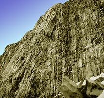
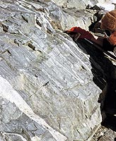
 Granite of the Taylor Pluton showing as a mere slice between the upper Peneplain Dolerite Sill and the lower Basement Sill at Solitary Rocks. The analysed cross section of the “Solitary Rocks Sill” I mention in 1966, was the Peneplain Sill but sampled a mile north of here, the 1962 samples came from out of view to right.. View South, with Mt Knobhead and the upper Ferrar just in sight left coming round it. Windy Gully spillover takes a shortcut from the Upper Ferrar on right. The flat ice plain below it, hidden by a slight bulge is a marvellous place for katabatic gales. Mt Terracotta with its dike swarm of FD is seen beyond Windy Gully. Granite of the Taylor Pluton showing as a mere slice between the upper Peneplain Dolerite Sill and the lower Basement Sill at Solitary Rocks. The analysed cross section of the “Solitary Rocks Sill” I mention in 1966, was the Peneplain Sill but sampled a mile north of here, the 1962 samples came from out of view to right.. View South, with Mt Knobhead and the upper Ferrar just in sight left coming round it. Windy Gully spillover takes a shortcut from the Upper Ferrar on right. The flat ice plain below it, hidden by a slight bulge is a marvellous place for katabatic gales. Mt Terracotta with its dike swarm of FD is seen beyond Windy Gully.The granite seems quite homogenous, with no invading dikes, obviously Post-tectonic, we (G & W) assigned the “Taylor Pluton” to a member of the Irizar Granite suite, though to be truthful I do not think we thin-sectioned the Solitary Rocks area. Does it include orthite??According to Stump, (1995, p113) other people who like to apply their own names have variously called it and the obvious extention to the Western Kukri Hills and lower down the Taylor Glacier, the “Catspaw Pluton”, the “Pearse Pluton”, the “Hedley Pluton”, or the “Vida Granite”,etc, well illustrating the confusion in granitic nomenclature! Lower down the Taylor Glacier, another 1000ft plus of the same granite is exposed below the Basement Sill near Lake Pearce. Notice how little weathering shows in the granite below the Kukri Peneplain surface, the darker material being scree. Scree littering the slopes of Knobhead quite conceals the sill limits. |
|
 << Yet another view of the Taylor Pluton taken by a passing electrician! Not perhaps as sharp as it could be but shows Lake Joyce below and that obviously the granite above and below the Basment sill are the same. That above the Basement sill over on the Western end of the Kukri Hills is also almost certainly the same. Below the sill?? I have sampled it a couple of times and such was my impression but samples were stored with Otago University who may still have them. << Yet another view of the Taylor Pluton taken by a passing electrician! Not perhaps as sharp as it could be but shows Lake Joyce below and that obviously the granite above and below the Basment sill are the same. That above the Basement sill over on the Western end of the Kukri Hills is also almost certainly the same. Below the sill?? I have sampled it a couple of times and such was my impression but samples were stored with Otago University who may still have them.
At mid-left, the granite is partly obscured by reddish dolerite scree and it would take a close look on foot. Cathedral Rocks are just out of sight beyond the Kukri Hills on left. The top of the icefall on Emmanuel Glacier can just be seen. View south. Close-up digi-camera pix of different exposures would be a great help. Thin sections as we showed for the Skelton Grandoirite can show large variations in K/spar – Plag ratio which may be real or may be sampling error. Only when the size of a homogenous sample is established is it worth while doing geochemistry. |
|
 |
<< The boulder behind which we are sheltering from any possibly wind from “Windy Gully” is lying on the Ferrar-Taylor medial moraine and is fairly typical of the basement rock exposed at intervals along the foot of the mountains in the near distance. It is typical of the “border facies” of some batholiths with inclusion of paragneiss and veins and dikes of aplite. It suggests that the Taylor Pluton does not extend west of the ice. The Terracotta Mtn dike swarm on left is Ferrar Dolerite in Basal Beacon Arenite. See the band of Early or pre-Devonian fine black shales low left. (1963) |
 << The Cathedral Rocks are three prominent bluffs on the south side of the Ferrar Glacer and due north of Mt Lister. Again we have an obvious border facies group with much sheared included calc-arenites and gneisses cut by aplite dikes. No granite is found east of here, but it extends SW up the Emannuel Glacier from the western Solitary rock, so this marks the probable eastern limit of the Taylor Pluton. << The Cathedral Rocks are three prominent bluffs on the south side of the Ferrar Glacer and due north of Mt Lister. Again we have an obvious border facies group with much sheared included calc-arenites and gneisses cut by aplite dikes. No granite is found east of here, but it extends SW up the Emannuel Glacier from the western Solitary rock, so this marks the probable eastern limit of the Taylor Pluton. |
|
 << Lake Bonney and the lower Taylor Glacier, viewed towards the Beacon Heights. << Lake Bonney and the lower Taylor Glacier, viewed towards the Beacon Heights.The sheet of Taylor Pluton granite seen between the two dolerite sill on the far Solitary Rock plainly continues into the nearer Solitary Rock. Lake Joyce and the Catspaw Glacier are out of sight to the right of the nearer Solitary Rock. Similar granite appears on the slopes of the Kukri Hills left, above and beyond the black McMurdo Volcanics monogenetic centres on the slopes left. Rock in the spur at The Narrows, has aplite dikes inrtruded into meta-calc-arenites and gneisses and appears to constitute more marginal facies but more distal than that seen at Cathedral Rocks. Does any Irizar-type Taylor Pluton rock extend further east than the basalt cinder cones? Without walking the length of the Western Kukri Hills we cannot at this time tell. There seem to be many dikes, possibly more marginal facies, on the right. Several people from Debenham down have said that the Irizar type granite appears above the Basement Sill in the western Kukri Hills and the Larsen biotite Granodiorite below. Ten miles north (to the right) similar granite is seen in a sheet between sills above Salina Pond in the Wright Valleys. Though Wilson and I went through it more than once in 1962 we did not collect as we were after dolerites, very silly! Again there seems to be no general agreement as to whether they are fact the same or not.That there can be so much dissent about a simple, well exposed granitic pluton of modest dimensions, makes one despair for the future of granitic petrology. One cannot help remark that confusion might be less if people read the original definitions! |
|
 A carbonatite dike in alkaline granite from the upper Koettlitz Glacier. Photo: Prof Cooper, Otago University. |
The Kukri Peneplain
This is an almost horizontal erosion surface cut across the Granite Harbour Intrusives of Ordvician age and has the Beacon Sandtone laying on it. The exact age of the base of the Beacon is not known, Devonian fossils lie about a thousand feet above the base but the underlying peneplaned granites give Ordovician (~450myr) ages. Although mentioned in almost every geological paper published in the last 35 years the amount of detailed information on this erosion surface does not seem to have increased that much but an ongoing search will be made for key facts. The peneplain surface is well marked by either yellow-grey-white sandstone resting on a basement of granites, gneisses and schists, or by a chocolate coloured dolerite sill about 1000 – 1200ft thick which has intruded in Jurassic time between the sandstone and the basement. This is called the “Peneplain Sill”. Conglomerates are often found near the contact.
 Kukri Peneplain. Seen a few miles south of Mt Suess, Granite Harbour at the entrance to the Miller Glacier. Pink and grey post-tectonic granites of Granite Harbour Intrusives are eroded to a horizontal surface. Except for a few barely visible slivers of Beacon Sandstone, the Peneplain Sill, (Ferrar Dolerites) rests directly on the peneplain surface. The Miller Glacier lies in a possible fault graben or eroded fault plane. One could land a 737 on the stagnant ice in the foreground. Kukri Peneplain. Seen a few miles south of Mt Suess, Granite Harbour at the entrance to the Miller Glacier. Pink and grey post-tectonic granites of Granite Harbour Intrusives are eroded to a horizontal surface. Except for a few barely visible slivers of Beacon Sandstone, the Peneplain Sill, (Ferrar Dolerites) rests directly on the peneplain surface. The Miller Glacier lies in a possible fault graben or eroded fault plane. One could land a 737 on the stagnant ice in the foreground. |
The peneplain surface is not only well seen in the Kukri Hills, in the Dry Valleys and Granite Harbour, it shows along the coastal mountains all the way to Nova Bay and to Nrthern Victoria Land. Dolerites and sandstone are known from Northern Victoria Land, and the continued existence of the Kukri Peneplain is probable and the accordance of summits seen in the Roberson Bay Group greywackes suggests it might have extended north-east to the Ross Sea and north to the Cape Hallet region. It can also be followed down the mountains south to the region of the Beardmore Glacier and to the Horlick Mountains, and probably much further, possibly right into the Indian Ocean coast in Queen Maud Land, but it does not seem to be well documented.
In Tasmania, dolerite sills are known to be intruded into flat-lying sandstone but glacier erosion has removed all overburden and the basement is not exposed though it may have been penetrated by drill hole by now.
The Karoo of South Africa consists of sandstones lying on basement intruded by sills and overlain by flows, but whether any equivalent of the peneplain exists we do not know though it should.
It is a great puzzle that the Ross Orogeny rocks should be peneplained so quickly, where did all the sediments go? It has occasional water channels in it, as though tidal. Below the Beaufort Sandstones (=Beacon) in the Karoo is an older formation, the Dwyka Tillites, and in South Africa at least, the land was peneplained by glaciation. However the McMurdo region was at least 2,500 miles away from the Karoo, even when the southern continents were still united in the Gondwana super continent. Then quite suddenly enormous amounts of sandstone and arkose, sometimes water laid but mainly aeolian arrive. From where? Was the land peneplaned near the coast while high granitic mountains still stood further inland? Was the Beacon deposition progressive? There is simply not enough exposure to say.
|
|
Coal-bearing Beacon appear 1500 miles away in the Prince Charles Mts near the Australian base of Mawson. Deep drilling has revealed Beacon down-faulted into McMurdo Sound at Roberts Point. How far towards Marie Byrdland does it occur? We do not know as yet. Does it occur under the centre of the Ice cap? Under the South Pole? One would think that examination of the peripheral continental marine sediments should show where the ice has passed over the easily eroded Beacon.
The final truth is we still know very little about the total extent of either the Kukri Peneplain nor the Beacon Sandstone. Both extend 2000 miles and can be seen occasionally for as much as 100 miles in width. Perhaps both are 2000 miles in width. They continue into the similar Karoo series of South Africa and into a small area of eastern Tasmania or, rather, did continue before the late Jurassic breakup of Gondwana. Coal-bearing sandstones of the beacon type continue up the East coast of New South Wales and southern Queensland.
Though the Beaufort formation in South Africa includes cross bedded sandstone, there seem to be more mudstone than is seen in the Beacon. Both have been intruded by almost identical dolerites sills of the same 165 myr (Jurassic) age.
Beacon SandstoneThough offset upwards and downwards by block-faulting, the Beacon Sandstones, which may be as much as 7000 ft thick, have remained almost horizontal, seldom tilting more than 10 deg. The block faulting makes it difficult to build up a complete cross section as there are not many fossiliferous horizons. Devonian fish and sharks occur at some height above the base (eg, see J.Long “Mountains of Madness”), Permo-carboniferous coals with the large lobate Glossopteris-Gangamopteris leaves and seeds, Triassic plant beds and thin coals and Jurassic coals and Ostraca beds are all seen west and north-west of the Dry Valley area, but large areas are quite barren. Pre-mammalian dinosaurs of many species are found in the Karoo and some of them at least (eg, Cryolophosaurus) also occur in the Beacon (especially high in Mt Kirkpatrick north of the Beardmore) and in Uraguay. Their presence and the presence of coal seams of up to 6m thick in the middle of what appear to be wind-blown desert sands is something of a puzzle, one can only assume intermontane swamps such as now occur in the Kalahari. Plant fossils have now been located in many areas and we will try to assemble a map of them. Trunks of trees of 2ft diameter showing strong seasonal rings argue a temperate climate at some distance from the South Pole in the Permo-carboniferous era at least. |
||
|
Cliffs several hundred feet high of somewhat silicified quartzite and arkose, either flat lying or cross-bedded, and totally barren of fossils or different lithology do not tell us as much as we might like!!However a great many short papers on the Beacon are buried in scores of, in some cases, rather obscure publications and we hope to slowly compile from them. Many formations have been named but it has yet to be shown that any have any great lateral extent. | |
|
Mt Crean in the Lashly Hills appears to be a dome, but a large block of Beacon has been tilted to the north by dolerite intrusion and the formation of wedge-shaped dykes | |
 |
<< Top of Permo-Carboniferous coal measures seam ( up to 6m thick), Allan Hills, Upper Mawson Glacier. Coal has been baked by Ferrar Dolerites and has very low volatiles and high ash content, but includes fossilised leaves and coniferous tree trunks. | |
 |
<< Coal outcrop found at the Allen Hills. There is one 18ft (=6m) coal seam and half a dozen of 1m and many thinner ones. Some have tree trunks of Glossopteris about 10in (=250mm) diameter showing well marked annual rings. The coal would find ready acceptance in the steel industry, is only 30 miles by ice road from the coast and is economically exploitable at the present day with an FOB value of close to $50 US per ton. (Coal Marketing Services Ltd, ChCh). With our current world steel production rapidly passing 1 billion tons annually, we may be forced to use such reducing sources within a century. (Aerial pic taken Dec.1957. Pilot Wm.Cranfield) |
|
|
|
Beacon Boomerang Range Skelton Glacier, South-western Neve region. Lower Beacon. We found Devonian fish remains in this area, possibly in these shales. |
|
 |
<< Ohio Range (Horlick Mts)
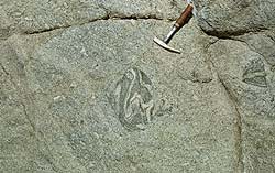
Permo Carboniferous Glossopteris Flora in the Beacon Sandstone coal measures. An apparently deciduous tree. Collected by Dr J. Aitcheson in 1983-4. Photographic study by Dr R. Ewan Fordyce, Dept of Geology, University of Otago, courtesy of the Otago Museum. |
|
 Glossopteris from Australia. >> Glossopteris from Australia. >>Again, more than one species may be present. The leaves are ovate to obovate and 4 to 6in long.Similar sandstones of the same age as the Beacon occur throughout Gondwana. Beacon type sandstones occur all the way up the Eastern coast of Australia as far as Rockhampton. All those sandy beaches south of Sydney, at Dee Why, the Gold Coast, Bribie Island, Caloundra, Moloolooba, Fraser Island etc are all relatives of the Beacon Sandstone and the great coal deposits at Wollongong and Newcastle are Permo-Carboniferous and are of general similar age to the Allan Hills Coal measures, the Weller Coal Measures, the Misthound Coal Measures in the Darwin Mts, the Mt Buckley Coal Measures at the head of the Beardmore as Grindley named them along with the nearby Dominion CM, and in the Ohio Range (Horlick Mts) which Long (1962) called the Mt Glossopteris Formation. We hope eventually to be able to show examples from most of Gondwana. |
||
Ferrar Dolerites
In Jurassic time, the whole pattern on plate tectonics underwent a massive change and new spreading centres which cut completely across the Gondwana super continent were activated. It appears that initially the massive volumes of magma formed by pressure release as crustal plates separated were in places trapped under crustal slabs. Perhaps at 165Myr, there was a short era of crustal compression. At least 100,000 cubic km of magma was forced up into the sundered crust, at first forming sills in the basement granites, then intruding along the Kukri Peneplain, then higher and sucessively higher in the Beacon Sandstones, finally errupting as lava flows and tuff on the surface. The lower sills may be 1200ft in thickness, those lying higher in the sandstone sometimes only a hundred or so. Feeder dikes washed away enormous blocks of light sandstone, forming linear masses of dolerite a mile or more wide, 30 miles long with 3-5000 vertical feet now exposed. See below.
The geochemical fingerprint of these rocks is typically continental and is seen in all continental flood basalts of this type in Tasmania, the Karoo, the Deccan (India), the Parana (Uraguay). For details on the chemistry and further pix see “The Geochemistry of Igneous Rocks”
 A massive stock of Ferrar Dolerites >>, Lashly Mts, ~10mi south of upper Taylor Glacier SVL. Height ~ 7000ft, taken from the Lashly graben. Rhythmic banding on right is composed by narrow bands of crystalline rock with variable amounts of glass, and little or no chemical difference. A massive stock of Ferrar Dolerites >>, Lashly Mts, ~10mi south of upper Taylor Glacier SVL. Height ~ 7000ft, taken from the Lashly graben. Rhythmic banding on right is composed by narrow bands of crystalline rock with variable amounts of glass, and little or no chemical difference. |
 << Dike Swarm on Rainbow Mountain, Taylor Glacier. << Dike Swarm on Rainbow Mountain, Taylor Glacier.The New Mtn Sill abuts into the large diagonal dyke on the right. Such a steep dyke swarm is unusal as in the Beacon, sills prevail. The height of exposure is about 3000ft. |
 Feldspathic band such as these are common in the thicker sills, both as anorthositic streaks of very calcic feldspar seen in the orthopyroxene layers of An85-80, and more sodic thicker layers of this type usually seen above the middle of a sill. >> Feldspathic band such as these are common in the thicker sills, both as anorthositic streaks of very calcic feldspar seen in the orthopyroxene layers of An85-80, and more sodic thicker layers of this type usually seen above the middle of a sill. >> |
 << With 10 – 200ft of the upper surface are pods, layers and bands of coarse pegamatite enclosed in augite-pigeonite-plag dolerite. Large sodic feldspars of An30-50 occur with ferrohedenbergite, iron ore, sometimes a little horneblende and includes large, (<1cm) sometimes cloudy, patches of quartz-sanidine intergrowths of micro-pegmatite. << With 10 – 200ft of the upper surface are pods, layers and bands of coarse pegamatite enclosed in augite-pigeonite-plag dolerite. Large sodic feldspars of An30-50 occur with ferrohedenbergite, iron ore, sometimes a little horneblende and includes large, (<1cm) sometimes cloudy, patches of quartz-sanidine intergrowths of micro-pegmatite.Photos by Mike Weiss, in Wright Valley, Basement Sill. |
 Probable lahar (The Mawson Fm) with pyroclastic Jurassic Ferrar Volcanics mixed with included fragments of Beacon Standstone and coal as well as basalt cobbles, Allan Hills, Upper Mawson Glacier. We originally described it as a post-Jurassic tillite, others later thought it a lahar. More recently a post Jurassic tillite called the Sirius Group has been described from here. Are they the same??Near here is the well-known Allan Hills Meteorite Ground. Probable lahar (The Mawson Fm) with pyroclastic Jurassic Ferrar Volcanics mixed with included fragments of Beacon Standstone and coal as well as basalt cobbles, Allan Hills, Upper Mawson Glacier. We originally described it as a post-Jurassic tillite, others later thought it a lahar. More recently a post Jurassic tillite called the Sirius Group has been described from here. Are they the same??Near here is the well-known Allan Hills Meteorite Ground. |
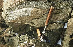
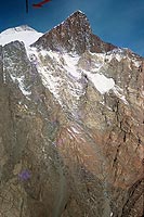
Ferrar VolcanicsPillow lavas of the Jurassic Ferrar Volcanics intruded into probably wet volcanic tuff, Carapace Nunatak, Upper Mawson-Mackay Glaciers at 7000ft. The Finger Mt Sill”, 1961, with the inclined Finger Mtn Sheet crosscutting it on skyline. Cliffs are of Lower Arenite, Beacon Sandstone. Western Kukri Hills from Ferrar Glacier, at about 2500ft, in Jan 1956. The basement Sill is intruded into granite. Remnants of the Peneplain Sill on the skyline. Dr Trevor Hatherton, Geophysicist, Lt.Cmdr. W.E. Smith RNZN are standing in foreground. My sledging companion Lt Cmdr Smith, RN; known as “Willie”. He sank the 44,000 ton battle cruiser “Takao” in Singapore Harbour from a midget submarine as well as a few German submarines and destroyers in his days as a destroyer man himself. (How’s that for a 50-year-old pic?!! He is not surrendering, he is laughing at his donated navy-blue mitts!) |
| Dolerites of the Vanda sill, Upper Wright Valley
|
| Collecting dolerites sample for geochemical analysis, Vanda Sill near the upper contact with bleached Beacon S/St.. |
 Collecting the Finger Mtn SIll for analysis, view down Taylor Glacier towards Lister. Collecting the Finger Mtn SIll for analysis, view down Taylor Glacier towards Lister.Collecting these kind of sill involves one in a little scrambling to get the Upper Chilled Margins! Antarciica needs nothing so much has a good West Coast shower of about 14in of rain in 3 hrs to wash away some of the rubble! |
 This is locally the “Peneplain Sill, having granite below and Beacon Sandstone lying immediately above. However it has a median autointruson of High-Mg orthopyroxenite with up to 60% OPX and 16% MgO while Cr and Ni increase by factors of 7 and 2.5 compared to the lower margin. This view is of the upper orthopyroxenites at about 600ft above the base.
The Kukri Hills as seen from Ferrar-Taylor medial Moraine
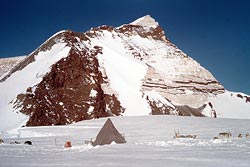
 This is the type area for the Ferrar Dolerites. View to east, taken 1955-6 summer. We see about 6-8 miles away the western end of the Kukri Hill Range, the Ferrar Glacier ice splits in two, half flows to the right down the Lower Ferrar Glacier, half swing left and join the Taylor Glacier to perish in the Taylor Dry Valley. We are camped on the medial moraine.
We see the lighter coloured more magnesian Basement Sill (about 900ft thick) intruded along a self-made parting in the massive post-tectonic Irizar Granite pluton. This sill has been autointruded by a late stage orthopyroxene cumulate mush with up to 30% Opx and 16% MgO, a lower proportion than seen in, say the Vanda Sill in the Wright Valley.
Above is the 1000-1200ft thick Peneplain Sill which has higher FeOT and is darker. It has no OPX cumulate, merely fairly constant augite-pigeonite (the latter often inverted to OPX plus lamellae of clinopyroxene). Lenses of granophyric micropegamitite are seen in the upper parts of both sills. A wedge of granite has been separated and lies beneath the sandstone to the right of the steep mountain glacier. On the summit is ~200ft of basal Beacon Sandstone. I don’t think we went above the upper dolerite so do not know if the basal conglomerates etc are present.
Katabatic winds polish the ice surface in the foreground. The shadow of a granitic boulder on right is the same one Scott camped beside in 1903. Notice there is absolutely no sign of wasting along the medial moraine, in fact the ice stands higher.
The ice stands about 50ft above the granite valley wall in the distance. A geological party once spent two weeks in this area without getting on to rocks, being unable to find a place to get down the marginal ice wall!
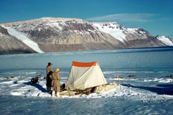
 Beacon Dry Valley Glacial Retreat. |
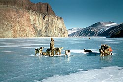
This was a very basic excursion, we had the clothes we stood up in, the two plastic banana-boat sleds, an awful little “Ronne”-type tent which slatted abominably in wind and had to be held down by brute force, and tropical army concentrate rations with no reserves beyond the 3 weeks we were away! Dinner would be a quarter sized can of spaghetti and sausage! Neither of the two men shown had been on snow before!
In the upper Beacon Dry Valley, ancient ice is obviously still preserved below thick ablation moraine. Esimates of it’s age run all the way up to about 2 myr. Table Mtn on left, Mt Feather rear left, Beacon Heights to the right but well out of view.
McMurdo Volcanics
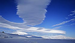 Castle Rock, Erebus, Terra Nova and Terror throw up lenticular clouds from a standing air wave. Photo: John Henzell. Gateway Antarctica |
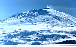 Mt Erebus Photo: Warren Hamilton |
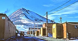 Observation Hill from Mac Town Photo: Warren Hamilton |
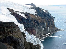
The main, present day block-faulted Victoria Mountains (sometimes called the “Trans-Arctarctic Mountains” were formed, possibly by a rejuvenation of the Ross Orogeny in the Tertiary “Victoria Orogeny”. As is usual while further folding may take place a depth, the surface expresson is one of block faulting. Parallel horst and graben structures are seen for 2000 miles across the continent. The main down thrown block lying immedately east of the Victoria Land coast allowed the accumulation of thousands of feet of glacial detritus being explored by the Cape Roberts Drilling project. Another effect was the eruption of large volumes of alkali-basalt, basanite finding access to the surface along the fault fractures.
Massive volcanoes of Pliocene-Recent age dated from 14.7 Myr to the present (Thomas Wilch) resulted extending from Cape Adare in the north, to Mt Discovery which lies about 20 miles south of McMurdo Sound. About 72 minor monogenetic centres have now been recorded from the Dry Valley area as well.
For further discussion on the chemical composition and for pix of the McMurdo Volcanics and the active Mt Erebus, see “Antarctic Oceanic Island Basalts”.
We will list all of the larger main centres from north to south and add pix when and if any become available. All seem to include both ankaramite, alkali basalt, hawaiite, mugearite, benmoreiite, trachyte and lesser amounts of basanite, trachybasalt, phonolite so we will not individually describe them chemically. There may be inaccuracies in this initial summary. Please correct us.
1/ Cape Adare. A north-south oriented fissure-controlled series extending for about 15 miles south of Cape Adare , and about 5000ft? high. Possession Ids which lie close to the coast separated by a narrow channel, may be a separate centre.
| 2/ Cape Hallett Volcano. Another fissure oriented series now formimg overlapping small shields, possibly at one time continuous with the Adare series. Described by W.Hamilton (Geol.Surv.Prof.Paper) and by Harrington et al 1965. These rest against Edisto Granite on the landward side and are lapped by the sea to the east. | |||
| 3/ Cape Daniells. These also may be part of the Hallett, Adare series, are of the same age and lie on the same coastal fault. They lie on the south side of the Tucker Glacier which separates them from the Hallett series to the north and may have eroded a channel through them. | |||
| 4/ Coulman Id, (73.5 S) lying closely offshore to the south and east of the C. Daniells series, has suffered considerable marine and glacier ersion but still stands about 6553ft (=1988m) and is glaciated on the NE side. Coulman Id shields the Lady Newnes Ice Shelf and large areas of bay ice lying to the south west. | |||
| 5/ Mt Melbourne, almost comparable to Erebus, while quiescent has active fumaroles and may still be active. It forms a 9000ft cone extending east to Cape Washington and and can be seen from both the German GANOVEX and the Italian Bahia Terra Nova bases close to Terra Nova Bay. | |||
| 6/ Mt Overlord. Again a symetrical cone lying on the north side of the Aviator Glacier Glacier with an unmodified summit caldera, north-west of Mt Morning. apparently of similar age and while there are no blatant signs of activity, may not be extinct. Mt Rittman nearby has fumaroles. | |||
7/ Franklin Island. A linear remnant lying out in the Ross Sea north of Ross Island. Basanitic scoria cones contain numerous large peridotite, harzburgitic nodules. Probably deeply abraded by the northern extension of the Ross Ice Shelf at the last glacial maximum at 20,000-10,000yr bp.
A nodule brought up from mantle depths, probably wehrlite ( Ol + Cpx) rather than Harzburgite (Ol + Opx). >> |
|||
| 8/ Beaufort Island, lying about 15 miles north of Cape Bird on Ross Island, | |||
| 9/ Cape Bird. (1765m) The northernmost of the cluster of centres making up Ross Island, Mt Bird was named for the penguin rookeries at its base, not for the Admiral. A symetrical shield lying over the northen rift of Mt Erebus. | |||
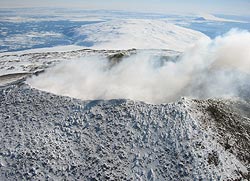
10/ Erebus (3795m). When we flew over the summit in March, 1957 we could plainly see red lava circulating in a deepseated lava lake within the summit caldera vent. It has been kept under observation ever since. Dr Phil Kyle is setting up a Erebus Volcano Observatory page. The composition is of nepheline phonolite and it periodically ejects small amounts of glassy lava with large (4in) anorthclase crystals.
The SWRZ forms a narrow ridge about 1000ft high and 20 miles long extending as far as the aegirine trachyte dome of Observation Hill at Hut Point. Several basaltic cinder cones are centered on it and the well known vent-breccia plug of Castle Rock. |
|||
| 11/ Mt Discovery is a symetrical extinct cone of about 9000ft lying about 30 miles SW of Hut Point. It has a SW rift Zone passing along Mt Morning and an easterly rift, similar to the Hut Point Peninsula, extending out to Minna Bluff for more than 10 miles. | |||
12/ White Island, Black Island and Brown Island are linear chains of centres rising perhaps 2000ft lying SE, south and SSW of Hut Point. The Dailey Islands lie SW and are considerably reduced by the abrasion of the Koettlitz Glacier. Other ice-abraded island in Erebus Bay are called the Dellbridge Islands, including Inaccessable Id and Seal Rock. |
|||
| 13/ There are now known to be 23 major volcanic Pliocene-Recent cones in Marie Byrd Land, Mt Siple for example forming a symetrical cone of 9000ft very like Mt Morning, on an offshore island. We hope, in conjunction with BAS to produce a second page on the Geology of West Antartica in which these will be listed. |