The Dry Valleys
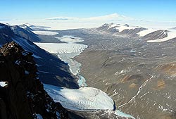
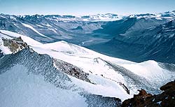
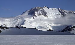
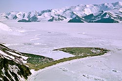
 A small hanging dry valley NE of Mt Mahoney. Granite Harbour lies through the gap to left. The Peneplain Sill (Ferrar Dolerites) lies on the Kukri Peneplain cut in granites, on the far side of the Miller glacier, Gonville and Caius Range. View to the east. |
I do not know who invented this appellation but these valleys are not THAT dry; in the summer one never has to go far to find water. I recall once crossing a river in the Taylor Valley with Cmdr Cadwallader USN who had done quite a bit of mountaineering in Kashmir, and he slipped off a boulder and fell in and I laughed my fool head off! They would be better termed “Ice Free Valleys” but they are not entirely ice-free either. There has been ice in Antarctica for about 34 million years at a guess, and for most of that time the Victoria Mountains have been doing a good job of preventing the main ice-sheet from flowing towards the Pacific.
However in a dozen places the ice spilled over and soon wore down deep valleys now filled with the Outlet Glaciers, which lowered the level of the ice cap to the point where very little ice still came down some of the shallower valleys. There may be barely enough to reach the sea, as we see in the Ferrar Glacier, or only a little which has all melted and ablated away before it gets half way there (Taylor Glacier), or gets melted and ablated after getting only a mile or so, (Wright Glacier), or doesn’t get anywhere at all (Victoria Glacier).
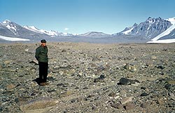
So where these glaciers once flowed to the sea, the ice has gone and the valleys for 60-70 miles are bare rock littered with old moraine. The time that has passed since ice filled these valleys is still very uncertain. It is about 10-20,000 years since the last temperature low but the ice seems to have been gone much longer than that. Measurements of the time that rock has been exposed to solar radiation give time up 2-3 up to 12 million years! More on this later.
Some of the short mountain glaciers lying west of the Koettlitz and which once flowed down to join it from the Southern Foothills are the same, just dry valleys littered with moraine with perhaps a short wall-sided glacier at the head.
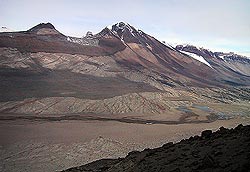
| Royal Society Range with Mt Rucker and >> Walcott Glacier as seen from Koettlitz. In spite of the height and proximiy of the sea in summer, the Walcott terminates as a wall-sided expanded foot. The foothills are of Ross System calc-arenites in the main with gneisses in foreground. A patch of McMurdo alkaline volcanics is seen middle left. Ferrar sills are rather erratic but the Kukri Peneplain lies at about middle height. |
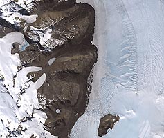
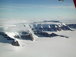
| Satellite view (USGS) of the Dry Valleys of the coastal range in the upper Koettlitz Glacier. The double Mears and Adams Glaciers are obvious with the Garwood shaped like a clenched fist. Heald island at the bottom. Note the high lines of stranded moraines (higher sealevel?). The Koettlitz seems to have almost distinegrated recently back as far south as Heald Island and refrozen. |
|
|
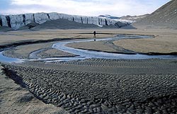
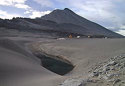
| The Garwood Dry Valley, in the Southern Foothills.
Another braided stream with unusally fine silt flowing from the the Garwood wall-sided Glacier. Another good site for plants! |
|
|
| The Adams-Miers Dry Valley with the Miers Glacier.
The runoff from two wall-sided glaciers combine to form a small stream which can flow at about 10 cu-secs into a usually frozen lake a mile or two west of the main Koettlitz Glacier. A drainage channel has been cut from the lake to the Koettlitz and the “Alph” River. The Royal Society Range lies behind with Mt Lister on right, then Hooker and Rucker. The lower spur to the left of Lister must be what we called “Corner Peak” which quite dominates the skyline when underneath it. |
|
|
| The Ferrar-Taylor-Wright-Victoria area
In 1902 a party lead by Armitage went up the Blue Glacier with a large party and the crossed over Descent Pass and dropped into the Ferrar Glacier just below Cathedral Rocks. Twenty miles further up they crossed into the Taylor Glacier and could see that the Taylor Glacier came to an end below Solitary Rocks and that a dry valley extended about 60 miles towards the sea. I do not believe it was entered until during Shackelton’s 1907 expedition when Dr Griffith Taylor and a companion walked down it almost to the sea and described the wall sided glaciers and other features. In 1911 Wright and Priestley spent several weeks in the Taylor Dry Valley. |
| The Upper Ferrar Glacier, >> an oblique, taken as part of a trimetrogon run by VX6 Squadron USN in 1955-6. The Mountain on right is part of Mt Knobhead which lies at the Ferrar-Taylor Junction (out of sight).
The Lashly Mts are seen in far right distance, the Portal is the gap leading to the Polar Plateau, with Portal Peak, the Boomerang Ra. and Mt Warren far left distance enclosing the Upper Skelton Glacier. The Portal is the main tractor-snocat-dog sledge egress to the Pateau. The overall view is SW. Mt Feather (9000ft) is the escarpment facing the Skelton before and right of the Portal. The Monastery lies at it’s left foot, with Corner Peak some miles towards the viewer. The spillover into Windy Gully can be seen right mid-distance. The upper Ferrar has never been completely traversed but appears to offer a much shorter (if icier) route to the Plateau. |
||
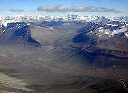
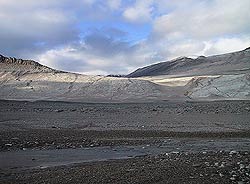
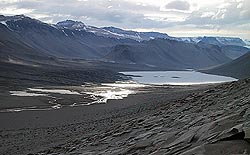
Taylor Dry Valley, >> The expanded foot of Commonwealth Glacier is seen entering on left only a mile or two from the coast, then Lake Fryxell, Canada Glacier centre left, Lake Hoare. Kukro Hills far middle right. See the sedimentary (limestone) rocks showing through maraine litter in the Nussbaum Riegel on right. Parallel lines in moraine at the break in slope of the Kukri Hills coud be old shore lines or ice levels. |
||
Near the sea in the Taylor valley especially, there are VERY old terminal moraines which could be a million years or so old. The Taylor Valley from near the sea, view west, 1955-6. Weathered moraine boulders include granite, gneiss, dolerite and lamprophyre. A rounded hill twenty miles up valley is the “Nussbaum Riegel.” The pointed dolerite capped peak on far right is the “Matterhorn” and the Canada Glacier, front right. In early 1956 three of us walked up the Ferrar and Upper Taylor and climbed North-west Mountain to get a view of the head of the Taylor as a possible tractor route. We could also see into the Wright Valley (the next to the north from the Taylor) and could see the barren Bull Pass and the generally snow free area around the Victoria Valley. A little ice came over a dolerite sill in an icefall I called “Wright’s Cascades” into the upper Wright Valley. |
||
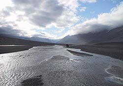
 The Wright Valley View north through Bull Pass into Victoria Valley. The small stream flowing west (into Lake Vanda) is the Onyx. Photo: Antarctic Images Library, Josh Landis. Halfway up to the lower contact of the “Basement Sill” is a ledge of “Pecten Conglomerate” marking an old sea-level. |
 Frost shattering of dolerite in the Dry Valleys leads to the formation of a skeletal soil on sunny slopes protected from too much wind. Nov 1957 |
In March 1957 when on TAE I wanted to get some flight time in the Beaver to photograph the area but there was a good deal of controversy from people who claimed that this was a waste of time, we were meant to be crossing Antarctic etc etc Finally John Claydon, our chief pilot out on a test flight took a look and confirmed the existence of several thousand square miles of ice free land. We then made several photographic flights over it, and informed the world and the next summer (1957-58), our ship-board biologist Dick Barwick and our resident biologist Dr Ron Balham joined a party down from Victoria University including McKelvey and Webb, of Wellington, and made a summer camp at Lake Vanda. The area has had visitors every year since. On our first recce over the area in March, 1957, we made a low transit through the Bull Pass (shown above), in the Beaver. I made a sketch map in a field book which we may show here later.
The deepest part of the valleys is often 20-30 miles inland from the sea and now there will be a frozen lake with no outlet, usually highly salty, partly from leaching, partly from evaporated seawater. In a warm summer, the lake levels get higher, but the streams that flow into them only flow in December, Jan-Feb and then only in the midday period. At “night” the sun goes behind the hills and the water stops flowing. I have seen water trickling down rocks in November on a calm warm and sunny day with the temperature away from the rock at about 10ºF.
 The view of the Wright Valley >> The view of the Wright Valley >>taken from the survey station on the summit of Mt Newall (which now has a micro-wave tower on it). It was also the Northern Party’s first survey point in Sept, 1957. It was the first time the floor of the valley was seen from the ground, we had flown low through Bull Pass (on right) in the Beaver six months before and in Jan. 1956 had seen the valley from North West Mtn, (skyline, left distance) but could not see Lake Vanda for example. We named some of the features but these were ignored by the stampede which followed some arriving even only a few months later as we had radioed out their existence after the Beaver flight in March, 1957. The stream in the valley runs inland towards Lake Vanda We are standing on the Lower Paleozoic Granite Harbour Intrusives. See how the Basement Sill thins out on the middle right. Don’t confuse with the dark detritus below it. The dark belt of rock near the valley floor on the left may well also be scree as Dr Bruce Marsh says. Mt Fleming in far centre distance with a Jurassic paleoflora, Shapeless (Triassic) partly obscured on the right distance with the “Wrights Cascades” icefalls between. We could see three mountains of about 10,000ft to the unexplored north-west, one a large shapeless mass, one had a tent like summit. and one leaned. We argued what we should call them, and Murray Douglas broke in saying ” For God’s sake, call them “Shapeless”, “Tent” and “Leaning Peak” and “Let’s get down out of here!” (It was about -20ºF). And so they are called to this day! |
|
<< Lake Vanda in the Wright Valley (out of sight immediately right) is the biggest. It has so much salt in it, that there is no convective overturn, the heavy highly saline water stays near the bottom and absorbs heat from the sun and stays quite warm in the middle of winter. I often wondered why they did not run a loop of pipe down and use it for heating in the days when there was a base there. The most saline of all is a small lake I called “Salina Pond”. We came upon it one hot day when very thirsty and without stopping to wonder what the inches of crystals were than lined it, we tried to drink! It is about ten times as thick as seawater, with calcium, sodium and potassium chlorides, nitrates, and perhaps some bromides. |
|
Bull Pass >> as seen from Wright Valley with Onyx River flowing west to left towards Lake Vanda. Granitic outwash gravels in foreground, with some retreatal moraine. Basement post-tectonic granites, (Granite Harbour Intrusives) cut by lamprophyre and more felsic dikes. Basement Sill of Ferrar Dolerites high in left partly directed by a lamprophre dike. Note the massive lower part of sill giving way to hexagonally jointed columns. Some fluviatile erosion down the median gut from the pass. The small terrace immediately below the pass on the right include Quaternary Pecten shells. It is believed to indicate a period of marine incursion when Pectens grew, probably under ice as gravels and stones above are compatible with being dropped from ice. I do not believe that the current depth of the ice in the Piedmont glacier is accuately known though it is believed that a rock sill is at present above sea-level, (Vucetich & Topping, “A Fiord Origin for the Pecten Conglomerates, Wright Valley, Antarctica.” NZJGS,1972) |
|
Sand dunes and an oasis in Bull Pass. Is the water fresh or saline? It seems no one has tasted it! Granites lie in forground, deeply weathered Basement Sill in middle distance, Mt Jason above. |
|
 View of a great geological cross-section of the southern wall of the Wright Valley as seen from Bull Pass. From summits downwards we see: View of a great geological cross-section of the southern wall of the Wright Valley as seen from Bull Pass. From summits downwards we see:(1) 600 – 1000ft of Peneplain Sill dolerite, resting on the almost flat Kukri Peneplain surface. Being more iron-rich, the rock is darker. (2) 5-600ft of granite cut by lamprophyre and porphyrite dikes, type of granite not known. on right a dolerite scree layer appears to rest on a horizontal dike. (3) About 800ft of Basement Sill with prominent horizontal layers of unknown origin. Fainter banding near top may be pegmatite layers, if there were not TWO prominent bands one might think they were the upper bounds of orthpyroxenite auto intrusion. Note lobe of dolerite on right which appears to be a separate pulse. Does it have a fine grained contact with the upper body to left?? Lower fine grained contact is darker, contact is somewhat sinusoidal. (4) Another 300 – 600ft of granite and dikes. (5) About 5-600ft of sub-horizontal dolerite scree with sharp upper and lower (not seen) margins. Bruce Marsh believes this to be all scree, but to have 3-4 miles of a parallel band of scree with sharp contacts would be most unusual. See the dolerite remains in place where swept by snow and water from the small glacier. In places a sharp contact shows through the superficial scree. If we have a second Sub-basement Sill it would have to be highly magnesian, probably olivine-bearing, as would be guessed from the lighter color. Scott Borg of USAP has promised to take a pick on his next visit! (6) In forground a somewhat tired glacial erratic or rock fall of unlineated post-tectonic granite with 2-3in potash feldspars, albite-andesine and hornblende. It has been subject to possibly a million years of weathering. Note parting in granite. Elsewhere a litter of dolerite, lamprophyre (dark black), porphyrite, granite and crystalline litter. Do I see a block of Beacon? Photo by Mile Weiss. |
|
Ephemeral Streams
There are so many small trickling streams at the height of summer that I think that arctic poppies, heath plants and dwarf willow would probably grow there now, if introduced, but introduction of plants into a continent that has none is not currently a politically correct thing to do. The man I travelled with had spent three years in Greenland and more than once he stopped and said “There is a musk-ox!” but it always proved to be a rock! One day, if the “politically correct brigade” can be thwarted, these streams may be vegetated. In another century they may be being farmed! Until some vegetation is established, all soil will continue to be blown away into the sea or Lake Vanda. The larger streams are seen in Victoria, Wright, Taylor, Garwood, Miers, Adams valleys but large supra-glacial meltwater streams can be seen on the lower Ferrar, Blue and Koettliz Glaciers especially, sometimes four feet or more deep. |
|
Lakes
The bluff at the end of the spur dividing the valley beyond the left edge of the lake is Basement sill at bottom with a step of granite. The Peneplain or Vanda Sill forms the escarpment along the far left wall of the Valley, the section collected in 1961 lies about the granite step. The left skline is formed of the northern spurs of the “Inland Forts”, the Amazing Grace Pass is seen high in left distance, (see below). Barely seen in centre right distance is “Northwest Mtn” from which we first saw the Dry Valleys in 1955-6, the lake was hidden from view by the central spur. Raised beaches may be seen on right. It is doubtful these indicate any long term climatic shift. A heavy spring snowfall and a few warm days would take the lake up to such a height very quickly.
|
|
PassesDue to lack of fluviatile erosion there are no deep narrow valleys and few low passes over ranges between major valleys and apart from a few due to ice erosion along faults or narrow grabens, low passes are almost unknown.
|
 Lake Vanda in the Wright Valley, view west with the creek entering below. Not the remnants of glacial scour on the dolerites in the fireground and lamprophyre dikes extending into the Lake.
 Salina Pond, or as I believe some people call it it; “Don Juan Pond”, lies in the south branch of the upper Wright. Halides, bromides and nitrates are so concentrated I do not believe it ever freezes. A concentration of salts washed from the locals screes, from wind-blown sea spray and from the saline lakes left after marine incursion formed a fiord, the salts have a mixed origin, and their geochemistry has been long investigated expecially by Lois Jones from OSU.
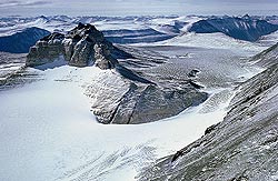 The “Amazing Grace Pass”
The BIG Mountains
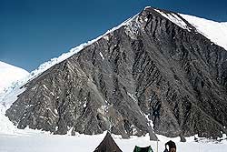
 Mt Harmsworth, (10,000ft) Now this mountain lying between the Skelton and Mulock Glaciers is not particularly huge, but it does have one point of interest. It was the first mountain to be climbed on the Antarctic continent according to “The Mountaineering World”. We ambled up it the day before (Jan. 1957), up the delta shaped bluff and then up the snow-ridge leading right. The actual summit is out of sight. It took 33 hours, the flat Skelton glacier we started on being afloat and so only a few feet above sea-level even though more than a hundred miles from open sea.
Mt Harmsworth is actually out of sight, the dome seen is about 9000ft. Seen from the northern side of the Skelton Glacier which is about six miles wide, (Feb. 1957). Medial moraine from the Cox Glacier on right. The Skelton which we first saw from the DC-4 in Jan.1956 became a major highway. A year later Bunny Fuchs of the TAE brought his sno-cats down here after crossing Antarctica. Three months earlier Sir E. Hilary took his farm tractors up on the way to the Pole and several dog-team parties passed up and down, altogether, 14 of them. Brookes and I dog-sledged down in Feb-1958. At least one American sno-cat seismic party also passed this way in 1959.
< Mt Huggins. This is the southernmost mountain of the Royal Society Range and faces onto the Skelton Glacier to the south. It is over 11,000ft; we climbed it in about late Feb 1958 from the glacier on left. We had to leave our dogs spanned out for the two days we were away. Mt Huggins. This is the southernmost mountain of the Royal Society Range and faces onto the Skelton Glacier to the south. It is over 11,000ft; we climbed it in about late Feb 1958 from the glacier on left. We had to leave our dogs spanned out for the two days we were away. |
||
| The Royal Society were highly antagonistic towards the RGS (Royal Geographic Society) which initiated Scott’s 1901-03 expedition. They tried to block Scott’s appointment and tried to block funds. To appease them, Scott named the most prominent range after them and their senior members, one being a certain Sir William Huggins. Scotts arch-enemy was Admiral Wharton, a naval hydrographer, who had a mountain further south named for him. |
|
|
Mt Lister at 13,000ft (4,025m) is not only the highest mountain in the Royal Society Range opposite Mac Town, it is the tallest from Cape Adare for a thousand miles to the Nimrod Glacier beyond which point up-faulting of the Queen Elizabeth Range crustal block has given rise to some even higher. Named for Lord Joseph Lister (1827-1912) of the Royal Society, Mts Hooker and Rucker lie beyond with Huggins at far left. Lister became professor of Surgery at Edinburgh when (despite the best of care) 50% of patients died from septaecemia after surgery. Lister’s suspicions of airborne infection were confirmed by Louis Pasteur and together with his introduction of sterile catgut and carbolic acid to sterilise wounds Lister reduced the death rate to 15% at which it stayed until Dr Alexander Fleming discovered penecillin. This mountain is a monument to a truly great man. In the foreground are folded calc-silcates of the Ross System. I once walked up to them and found diopsidic rocks with green 1cm pyroxenes. The Peneplain Sill can be dimly see about half way up the escarpment with irregular blocks of Beacon Sandstone above. The basement immediately below the summit is of granite. |
||
| Mt Herschel, ~ 11,000 ft. seen from Cape Hallett Bay, 1972. This peak was climbed by Dr Mike Gill and partner, in an expedition in 1969 led by Sir Edmund Hillary. Rocks are almost all Roberston Bay greywackes, see the anticlinal fold at the summit. Photo: Murray Ellis, 1969. |
 |
|
 |
||
| Mt Albert Markham. Named for his work in the north Pole area, especially on the searches for Sir John Franklin and the lost “Erebus” and “Terror”. A flat-topped mountain lying south of the Barne (=Byrd) Glacier on the edge of the Polar Plateau. |
||
 Mt Clements Markham. (4350m) Mt Clements Markham. (4350m)A not very good pic taken on the USN DC-4 Jan.1956 photographic mission, (Cmdr Hank Jorda and Capt. John Donovan) where I was ‘Observer’. Mt Clements Markham (4350m) is the highest Peak in the Queen Elizabeth Range between the Nimrod and the Beardmore Glaciers. Lowery Glacier in the foreground. (named for geologist James Lowery who lost both feet to frostbite in the 1959 Sno-cat crash). Rocks are Beardmore Group isoclinally folded Ross System calcic greywackes, quartzites and calc-arenite, of Upper Paleozoic to L. Cambrian age. (Gunn & Walcott, 1962.) They seem to extend to unusual elevation possibly to the summit as can be seen below.It is now known that Clements Markham is exceeded in height by Mt Kirkpatrick (4528m) which lies W of the Beardmore to the left. Sir Clements was the driving force behind the RGS which sponsored Scott. He, almost alone, picked Scott for his ability, drive, leadership qualities, interest in science, and humanity which were to make him the greatest of all polar explorers.  Mt Clements Markham seen from the East. We see that dark greywackes of the Goldie Fm and light colored, probably Cambrian Shackleton Limestones are seen right to the summit. In other words the Kukri Peneplain has been elevated to 15,000ft (about 5km), the all time high. At the Kar Plateau at Granite Harbour the Kukri Peneplain or a flat eroded surface which is almost certainly it, lies at about 2-300ft compared to about 800ft to the south on the Miller Glacier. Photo: Beth Bartel. Mt Clements Markham seen from the East. We see that dark greywackes of the Goldie Fm and light colored, probably Cambrian Shackleton Limestones are seen right to the summit. In other words the Kukri Peneplain has been elevated to 15,000ft (about 5km), the all time high. At the Kar Plateau at Granite Harbour the Kukri Peneplain or a flat eroded surface which is almost certainly it, lies at about 2-300ft compared to about 800ft to the south on the Miller Glacier. Photo: Beth Bartel. |
||
| Mt Clements Markham from the E or SE. >> The Robb Glacier in the foreground flows into the Ross Ice shelf, the Lowery Glacier in the middle distance, into the Nimrod. Goldie Fm greywackes and some Hope Granite on forground. Mapped in 1969-60, (Gunn and Walcott,1961). Note the series of five unconfomable icefalls probably indicating recent uplift of the Queen Elizabeth tectonic block. Photo: Beth Bartel. |
 |
|
| Unlocated mountain near the Beardmore >> Probably Mt McKellar, viewed from the Beardmore Camp in the Walcott Neve. There appears to be a disconfomity in the Beacon but may be due to dolerite intrusion. (Kristan Hutchinson, USAP Image File.) |
 |
|
 Horlick Mts, East Antarctica (Jack Holt Mts.??,>> 2003) Horlick Mts, East Antarctica (Jack Holt Mts.??,>> 2003)This interesting shot is taken of one of the most easterly scarps where the Victoria Mts (= TAM) fade as they approach the Weddell Sea. Holt was an electronic tecnician flown out to set up a seisimic station and took some interesting pix in passing. He believes this to be part of the “Wisconsin” range which is another name for the Horlicks. Several parties who have worked in this region have been asked, none can identify it. The basement granites, the Kukri Peneplain, the Peneplain Sill and the overlying Beacon Sandstone are all plainly seen. Cape Surprise, near Shackleton Glacier was named because of the unusual occurrence of Beacon Sandstone near the coast as seen here, but comparison with maps does not seem to support the idea that this could be Cape Surprise. |
||
 Dufek Massif Dufek MassifThis isolated range lies even further east. Dr Art Ford and others found a huge layered gabbroic intrusion here in about 1962, comparable to the Stillwater Intrusion of Montana. Obviously related to the Ferrar Dolerites, it has orthopyroxene cumulates, anorthosites and thick lenses of magnetite and some chromite. The top and bottom are not seen but the foreground rocks are granophyres usually found near the top of such intrusions. If Art Ford can be located, we may be able to show close-ups of these unusual rocks. Where art tha’ Art? |
||
We would like to show pix of all the main mountain ranges but so far have not been able to locate so much as a shot of Mt Kirkpatrick, Mt Fritjof Nansen, Mt Betty, the Patuxent Range etc. – contributions invited!
Antarctic mountains are seldom difficult but it can get cold up there, the worst danger is from frost bite. Without any rain to keep them clean, mountainsides are usually littered with rubble and loose rock.
Raised Beaches
| Cape Hallet… |
|
Glacial Erosion
| Delta Bluff, 4000ft of Diorite with some included limestone, the first step on the ascent of Mt Harmsworth. The Skelton Glacier in the foreground consists of 3000ft of ice afloat above another 2000ft of water. In another 5000 years it might be a nice fiord. Truncated spurs such as this caused by ice erosion are found only in a few antarctic valleys. The flow is right to left but notice absence of ice polish etc right down to ice level. |
 |
|
|
|